- Departing CYYG, landing CYYG (Charlottetown, PEI), "VFR along entire coast of PEI clockwise"
- Departing CYQM (Moncton) for CCN2 (Grand Manan), "Fundy coastline T/G CYSJ coastline to CCN2"
- Departing CYFC (Fredericton) for CYHZ (Halifax), "Saint John River Fundy coastline Martin Head Cape Chignecto Cape Split"
Another important part of any VFR flight is also the same as IFR: A weather briefing. Very important. In fact, maybe even more important for VFR than IFR. An IFR flight encountering IFR weather just calls ATC for IFR clearance as an "airfile" and flies IFR. A VFR flight encountering IFR weather may be in very, very deep trouble. The good news is, trouble that deep doesn't normally last long (dark humor?). In either case, it is very important to make sure that the weather is VFR at point of departure, VFR along the intended route of flight (sometimes waterways cause local phenomena like a fog bank), and VFR at destination until a reasonable period of time after the ETA at destination.
Whoops. I almost forgot. There's another segment of the IFR preflight that's important to VFR flights, too. Checking the NOTAM summary. Yes, very important. Perhaps even more important in some ways for VFR than for IFR. The reason I say this is because often there are small areas of temporarily restricted airspace along the route of flight that might be lower than minimum IFR altitudes, thereby not affecting IFR flights. Forest fires often have restricted areas established around them. Other examples include areas established for security reasons (specific facilities, high profile local conflicts, etc).
Route of Flight
For our VFR flight, our pilot is departing Moncton, NB, for Halifax, NS. The designator for the Greater Moncton International Airport is CYQM, and Halifax International's designator is CYHZ. The aircraft of choice for this flight will be a Cessna 172, namely the one with the civil identification C-GOOF. The preflight revealed good weather at both point of departure and destination, as well as all points in between. This is good, because the cold waters of the Bay of Fundy often bring localized fog over this area. An easy way around this for the experienced pilot is to fly a few extra miles and go inland, thereby avoiding the fog banks over the bay. In any case, for the heck of it, our pilot has decided to do a touch and go at Debert, NS, whose designator is CCQ3, about half way in between. Our pilot is intending to fly basically a direct flight from CYQM to CCQ3, then following the highway to CYHZ. Since the first leg is eastbound, 3,500 is chosen for the altitude (don't want to fly too high for good sightseeing). The second leg is westbound, and therefore requires a different altitude. 4,500 is chosen for this leg.
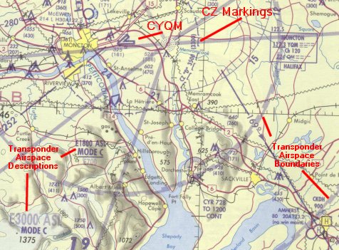 Starting with the point of departure, Moncton, our pilot has determined
from the Canada Flight Supplement that CYQM has a control tower, and
a class D control zone with a 7 NM radius and a cap of 3,500 feet. CYQM is,
therefore, a controlled aerodrome. No big deal, to be sure, but nice
to know what you're dealing with.
Starting with the point of departure, Moncton, our pilot has determined
from the Canada Flight Supplement that CYQM has a control tower, and
a class D control zone with a 7 NM radius and a cap of 3,500 feet. CYQM is,
therefore, a controlled aerodrome. No big deal, to be sure, but nice
to know what you're dealing with.The airspace surrounding Moncton is Class E Transponder Airspace, meaning our pilot needs a Mode C transponder to operate in it. You can see this from the markings "E1800 ASL MODE C". This means the Class E transponder airspace actually begins at 1,800 ASL out to 15NM from CYQM. Further out, to about 25 NM from CYQM, it begins at 3,000. If the transponder in the plane didn't work, he could still get out. He'd just have to fly below these altitudes within these distances. The CZ itself is Class D, but not transponder airspace, thereby allowing the TWR to look after local traffic without a transponder. Our pilot, while enroute to CCQ3, will be following a track not far off the 169 radial, east of it actually, visible on the eastern portion of this image. This radial is actually V313 between YQM and YHZ VORs. If I included more of the map, you would see a label indicating such.
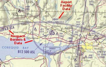 Examining the route of flight he plans, CCQ3 is in Class E airspace, and
has no tower. This means Debert is an uncontrolled aerodrome. Debert
has an Aerodrome Traffic Frequency, or ATF. From the "data tag" printed
just above the triangular runway depiction at CCQ3 you can see that Debert
is 142 ft above sea level, is lighted (the L in the box), its longest runway
is 5000 feet. Its ATF is 123.0, and transmissions will be directed to "Debert
Traffic" around CCQ3. Debert is actually within the Halifax Terminal Control
Area (TCA), which our pilot learns more about as he scans the charts...
Examining the route of flight he plans, CCQ3 is in Class E airspace, and
has no tower. This means Debert is an uncontrolled aerodrome. Debert
has an Aerodrome Traffic Frequency, or ATF. From the "data tag" printed
just above the triangular runway depiction at CCQ3 you can see that Debert
is 142 ft above sea level, is lighted (the L in the box), its longest runway
is 5000 feet. Its ATF is 123.0, and transmissions will be directed to "Debert
Traffic" around CCQ3. Debert is actually within the Halifax Terminal Control
Area (TCA), which our pilot learns more about as he scans the charts...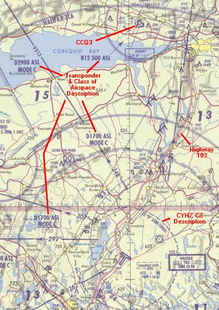 The airspace surrounding Halifax International is Class D. This means
he must be in contact with ATC, in this case Halifax Terminal, prior to
entering the Class D airspace. The Halifax Terminal Control Area (TCA) is
transponder airspace, meaning he needs a Mode C transponder in there. The
altitudes are written inside the areas as appropriate, in the same fashion
as described for the Moncton image above. Notice, though, how Debert itself
is within a little "notch" in the Class D airspace. This means that it is
actually excluded from the Class D, so aircraft without transponders can
get in an out, and they don't even have to call Halifax Terminal in the immediate
area, or north of, CCQ3. Closer in, Halifax has a tower also, and it, too,
is in class D airspace, though not transponder airspace.
The airspace surrounding Halifax International is Class D. This means
he must be in contact with ATC, in this case Halifax Terminal, prior to
entering the Class D airspace. The Halifax Terminal Control Area (TCA) is
transponder airspace, meaning he needs a Mode C transponder in there. The
altitudes are written inside the areas as appropriate, in the same fashion
as described for the Moncton image above. Notice, though, how Debert itself
is within a little "notch" in the Class D airspace. This means that it is
actually excluded from the Class D, so aircraft without transponders can
get in an out, and they don't even have to call Halifax Terminal in the immediate
area, or north of, CCQ3. Closer in, Halifax has a tower also, and it, too,
is in class D airspace, though not transponder airspace.So the final route of flight will be filed as CYQM as point of departure, speed of 120 knots true, "DIRECT CCQ3 T/G N0120A045 HIGHWAY 102" for the route (note the altitude change for the direction of flight change which must include the speed, even if it doesn't change), CYHZ for the destination, and our pilot figures a total time enroute of 1+20, including an allowance for the climb form CYQM, the descent and pattern at CCQ3, the climb out to CYHZ, and the pattern time at CYHZ. Winds from the preflight weather briefing were, of course, considered when calculating this.
I apologize for the huge size of the images, and the relatively poor quality of the scans. To show the details I wanted to, I had to include these, but the image sizes for Moncton and Halifax were initially over 8MB each. I had to trim them and reduce the resolution to get what I thought would be useful (or at least interesting). One last note: The charts are oriented on true north, not magnetic north. We know that cruising altitudes (westbound and eastbound) are determined based on magnetic tracks. So even though CCQ3 to CYHZ looks very close to a straight south line (which is included in westbounds, designated as 180-359° inclusive), it is actually well inside the westbound portion, since magnetic variation around this area is 20°W. This means that the chart could be legitimately be rotated 20° to the right. Want more proof? Look at the radials published off the YHZ VOR. They're marked in degrees magnetic. Orient those correctly, and you'll see what I mean. Our track from CCQ3 to CYHZ would, therefore, be about 195-200° if we were to fly direct, but it's even further west, since the pilot is planning to fly along Highway 102 which closely underlies V310, the most easterly airway visible in this image (the reciprocal of 029° would be 209°).