Aviation Topic of the Week
By Michael Oxner, September 14, 2003


Introduction
Previous Week's Topic
Following Week's Topic
Aviation in Canada Blog
Archives

This week's topic:
IFR Flight Part 6b: Flight Plan Parts

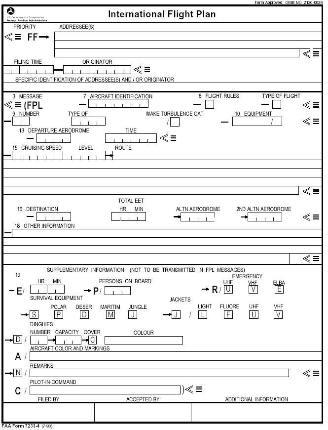
This is the continuation of last week's topic of flight plans. The AIP RAC 3.0 is our reference for the following information. This week, we look more specifically at the fields of the standard ICAO flight plan form. For this topic, the index below will refer you to information for each specific section. Also, the items are grouped according to the "field number" on the standard ICAO flight plan form.

ICAO Flight Plan Example Image
Item 7: Aircraft Identification
Item 8: Flight Rules & Type of Flight
Item 9: Number and Type of Aircraft, and Wake Turbulence Category
Item 10: Equipment
Item 13: Departure Aerodrome and Time
Item 15: Cruising Speed, Altitude/Level, and Route
Item 16: Destination Aerodrome, Total Estimated Elapsed Time,
                SAR Time and Alternate Aerodrome(s)
Item 18: Other Information
Item 19: Supplementary Information
Flight Planning Information in Canada, in Real Life

Well that looks like a lot, doesn't it? Not all flight plans will require all the fields above, but most will require most.

ICAO Flight Plan Example Image

Have a look at this image, and feel free to return to it with the discussions on the "Items" referenced below.
ICAO FP Form


Item 7: Aircraft Identification

Normally, this is meant to contain the aircraft registration letters or the company designator followed by the flight number. Many military flights use tactical callsigns. This field is a maximum of 7 characters, letters and numbers only.
Item 8: Flight Rules & Type of Flight

A simple one-character field, indicating which type of flight rules the pilot will comply with. The options are I for IFR, V for VFR, and then there are a couple of letters for composite flight plans. A composite flight plan is one where the pilot intends to start out on one type of flight rules, and change while enroute to another type. The remaining options are Y, for IFR then VFR, and Z for VFR then IFR.

If Y or Z were to be used, the pilot should specify in the route section the points where a change in flight rules is planned. See the Route section below. If there is more than one change, the letter to be entered is to reflect the first change. For example, IFR/VFR/IFR should be filed as "Y".

For the Type of Flight, up to two characters are entered following the last entry above. The first character is for Canadian flights only, and it can be C for CVFR, D for Defence VFR, or DVFR (where the flight is operated in accordance with VFR and at least partly operated within the Canadian Air Defence Identification Zone, or CADIZ), E for Defence Flight Itinerary, or F for Flight Itinerary. The second character is ICAO, as required. The options are S for Scheduled Air Service, N for Non-Scheduled Air Transport Operation, G for General Aviation, M for Military, and X for Other.

For all the typing I did for this last section, I think VatSim is only set up to deal with I and V from the first paragraph, so the rest has no bearing on VatSim flight plans. Aren't you glad I wrote all this?

Item 9: Number and Type of Aircraft, and Wake Turbulence Category

This field includes a few characters, all alphanumerics. First, the number of aircraft, as 1 or 2 digits. The type of aircraft is two to four characters, and it is meant to be the ICAO designator for the aircraft type. Sometimes, these match (for example, a DC10's designator is DC10) but not always (such as the BAe 146-200, whose designator is B462). Luckily, VatSim takes care of that for us in SquawkBox 2.3 by having a list of aircraft to select from. Examples?
If more than one type of aircraft is in formation, or the type of aircraft does not have a designator, the OTHER field (Item 18) mentioned below should be used, preceding the aircraft type information with "TYP/".

The Wake Turbulence Category is filed by "H" for Heavy, "M" for Medium, and "L" for Light. Again, VatSim takes care of that for us with the list of aircraft types mentioned above.

The order mentioned here is not necessarily what shows on the ATC radar, and may not be the same for the domestic flight plan form for whatever country you're operating in. This is the ICAO standard, though.

Item 10: Equipment

This one is a standard that is not really standard. I've seen many interpretations of each letter, and only a few seem to remain the same. Canada has one list, the US has another, and ICAO another still. I'll comment here on the ICAO list, since that's my reference out of the AIP. I'll quote from here to the end of this item from section RAC 3.16.4.

(a) COM/NAV/ Equipment
    Insert one letter as follows:
    N    if no COM/NAV/approach aid equipment for the route to be flown is carried, or the equipment is unserviceable; or
    S    if standard COM/NAV/ approach aid equipment for the route to be flown is available and serviceable. (Standard is VHF, ADF, VOR and ILS)

    AND/OR insert one or more of the following letters to indicate the COM/NAV/approach aid equipment available and serviceable:

A
(Not Allocated)
M
(Not Allocated)
B
(Not Allocated)
O
VOR
C
LORAN C
P
(Not Allocated)
D
DME
Q
(Not Allocated)
E
(Not Allocated)
R
RNP (RNPC)
F
ADF
T
TACAN
G
GNSS (GPS)
U
UHF (COMM)
H
HF RTF
V
VHF (COMM)
I
INS
W
RVSM
J
Data Link
X
MNPS
K
MLS
Y
CMNPS
L
ILS
Z
Other Equipment (Specific in Item 18)

There are some notes to go with this stuff above, too. For "J", the data link, the type of link equipment is to be specified in Item 18 for Other Information. For "R" to be filed legitimately, the equipment on board must meet the requirements for the airspace where the flight will occur. Since ATC only sees one equipment suffix and "G" falls below other forms like "W", "X" and so on, ATC may not know you have GPS certified for IFR flight. In non-radar airspace, this might affect the separation standards chosen by ATC, so it may occasionally serve you best to remind ATC you have GPS. In a radar environment, this information will make no difference.

So if you're filling out an ICAO form, and you're operating a Beech Baron with standard equipment as mentioned above, but you also happen to have HF radios and a GPS unit (this is meant to be one certified for operation during IFR flight, TSO-129C), you would file as such in the equipment list:

SH/G

Incidentally, if you're VFR, they encourage you to mention that you are using GPS to assist navigation. Remember, in past topics, VFR flight's primary method of navigation should be looking out the window, not the instruments. It's fine to use NAVAIDs and GPS to guide you, but you still have to look out the window to fly.

Item 13: Departure Aerodrome and Time

The first part is simple, the 3- or 4-letter identifier for the departure aerodrome, if one exists. If no designator exists for the departure point, use "ZZZZ" and specify the departure point after entering "DEP/" in Item 18 for Other Information mentioned below.

The Time is simply the proposed departure time in UTC, always 4 digits. For example, 0400.

Item 15: Cruising Speed, Altitude/Level, and Route

First a couple of notes. The AIP mentions that IFR flights may be conducted at or above the published MEA/MOCA for an airway segment except during winter when air temperatures may be much lower than the standard ICAO atmospheric conditions. This would lead to lower altimeter readings than usual. Hence, during winter months, a pilot should flight plan at least 1,000 feet higher than published MEA/MOCA information.

Secondly, there are many occasions where Preferential Routes exist. Typically, only flights into or out of higher traffic airports are affected by such things. They are published in the Planning of the Canada Flight Supplement. Pilots are encouraged to file these routes, though not required to do so. ATC may, when issuing an IFR clearance, issue the pref routing, and the pilot must comply if able. If the pilot is unable, he should inform ATC of the reason and request an alternate route.

Always start at the beginning for these items. When I say, "leg" in the following statments, I'm refering to the idea of changing altitudes or speeds, or even direction of flight, as opposed to taking-off and landing more than once in a flight plan. Since flight plans may contain multiple legs, and each leg may contain a different altitude and speed request, the rest have to be entered in the route field where the changes are planned. There are three ways to express speed: Prefix speeds with K for kilometers per hour (ICAO only), N for Knots, and M for Mach Number. Both K and N require entry of 4 digits, while M requires only 3. Examples? "N0170" for 170 knots true airspeed, and "M082" for Mach 0.82.

For Cruising Level/Altitude, there are a few methods available as well. Meters can be used in certain airspaces, and that is entered as "S" followed by four digits. If it is desired to enter altitude in tens of meters, "M" is used, also followed by 4 digits. What could cruise a 99990 meters? Anyway, these are not used in VatSim. "A" is used to express cruising altitude in feet, and is accompanied by three digits representing the altitude in hundreds of feet. 10,000 feet would be expressed as "A100", and "A045" would mean 4,500 feet. Where cruising levels are to be flight levels (above transition altitude, oceanic airspaces, etc), "F" should be used followed by three digits indicating the flight level. "F200" is Flight Level 200, for example. Also, for ICAO only, VFR flights that are not controlled by ATC can be abbreviated with the entry of "VFR", which is how ASRC sees the altitude data on a flight plan. See the table below for examples.

Now on to the Route section. Use ICAO designators for NAVAIDs, five-letter fixes, airways/air routes, etc, in the route portion. This can be complex. Sometimes the pilot intends to fly directly from one point to the next, where no airway is established. The ICAO way to indicate this is the expression "DCT". The Canadian way is simply to put the two fixes side by side with a space as a separator. ICAO: YHZ DCT YYT. Canadian: YHZ YYT.

Now we get more complex. For flights outside ATS routes, like oceanic routes not on the North Atlantic Tracks, use positions that are not more than 30 minutes flying time, or 200 NM apart, including fixes where a change in level or speed are planned. This could include ICAO five letter fixes or NAVAIDs where available, but if they're not, you should use latitude and longitude, or bearing and distance from a NAVAID, and these are properly expressed as follows. Wherever a change in altitude or speed is planned, this information should be included in the route immediately after the fix where the change is planned. Also, if a change in only one of those two items is planned, both must be specified. In the following examples, the flight is planned from CYHZ to CYYT on J575 (YHZ, YQY, YYT). Initially, the flight is planned at 300 KTAS and FL210. This is what should be entered in the route box for the following conditions.

Situation
Route Box Entry
Straight forward, no changes planned
J575
Changing the requested altitude to FL250 at YQY
J575 YQY N300F250 J575
Changing the requested altitude to 15,000 feet at YQY, then the airway to V312 because of the altitude
J575 YQY N300A150 V312
Changing the requested speed to 350 KTAS at YQY
J575 YQY N300F210 J575
Changing both speed and altitude at YQY
J575 YQY N350F250 J575
Changing from IFR to VFR at YQY, planning 11,500 feet and 250 KTAS
J575 YQY VFR N250A115 V312

If any of these details I'm writing about today is to be used in VatSim, I'd personally like to see this section put to use. Simply requesting altitude changes enroute in the flight plan as so easy, and ATC should be able to recognize this. It is not, however, a VatSim standard, so if you use this stuff, don't be surprised if the controller doesn't recognize it. I'm not even sure of the implications and effects on ASRC, if indeed there are any, of using this kind of formatting.

If a cruise climb is planned, this can be entered in the same manner as described above where the cruise climb is planned by entering "C/" (C plus the slash) followed by the point where the climb will commence and then a slash, and then the altitudes which will be occupied during the transition. Alternatively, this last bit of information can be entered including the level above which the cruise climb is planned, followed by the word "PLUS", without spaces between them. Here are the AIP's examples:

C/48N050W/M082F290F350
C/48N050W/M082F290PLUS
C/52N050W/M220F580F620

Note the last example is planning a speed of Mach 2.2.

Item 16: Destination Aerodrome, Total Estimated Elapsed Time, SAR Time and Alternate Aerodrome(s)

As with the departure aerodrome, this is started with the 3- or 4-letter designator for the aerodrome, or ZZZZ if there is no designator. If ZZZZ is used, Item 18, Other Information, discussed next, should contain this information written in plain language following the notation "DEST/".

The Total Estimated Elapsed Time is the estimated time enroute, along with the time of any stopovers, expressed as a four digit grouping including hours and minutes. For example, 4 hours and 30 minutes enroute would be written as 0430. For IFR flights, a flight plan cannot include stopovers. A new flight plan must be filed for each leg. An IFR Flight Itinerary may include stopovers. See last week's topic for notes on when an IFR Flight Itinerary may be filed instead of a flight plan. Since we in VatSim can't do FIs, I won't get into the specifics of FI EETs.

SAR Time, or Search and Rescue time, may be added. Normally, ATC goes looking for a flight if it goes overdue. A flight is overdue if an arrival message is not received within 30 minutes of the time the flight is expected to land. This gives the pilot the opportunity to make his way to a telephone if he lands at a field not served directly by an ATS unit. If the standard time isn't what the pilot wants, this should be noted in this section of the flight plan, expressed as a four digit grouping including hours and minutes as above, and may be a maximum of 24 hours beyond the EET.

Ah, the dreaded Alternate Aerodrome(s). Did you manage to digest all that from last week? The ICAO 3- or 4-letter designator should be used, with ZZZZ being entered where no designator exists. If ZZZZ is used, "ALTN/" should be entered in Item 18, followed by the plain language description of the place.

Item 18: Other Information

Finally, the infamous Item 18. Enter "0" (zero) if there is no other information. Good enough? OK, let's move on.

I wouldn't do that to you. This is the place for all other information that couldn't be written elsewhere in the plan. The sort of, "Free form" part. Free in the sense that other stuff can be entered, but there are still official notations here. This could be an entire topic of its own. If really necessary, you can look this up in the AIP. If popular demand comes back to haunt me, I'll do a separate follow up to this one and include more details. Write me if you want to see this.

Item 19: Supplementary Information

Again, there is a lot of information here. The important parts are:
I'll leave the rest up to you. The example image above should be clear enough to allow you to peruse this information and get a basic insight as to what this all means. None of this other information is available to VatSim flight plans, and it's probably a good thing. Items like pilot's name and license number, aircraft colors and markings, etc, all go here. It would be more than is required, for sure, for a flight in the virtual world.

Flight Planning Information in Canada, in Real Life

As usual, my unofficial watchdog Greg Phelan has mentioned something to me. I use it myself when I'm planning a real world flight, and we both thought you might at least find the site interesting, if not useful. Nav Canada is the provider of Air Navigation Services in Canada (in most places, anyway), and their website has a section devoted to flight planning. Here, weather information like METAR and TAFs can be picked up, as well as SIGMETs, PIREPs, and NOTAMs talked about in the previous week's topic. If you've never seen some of this real world information, it would be worth taking a look at. Here's the address:

http://flightplanning.navcanada.ca


*Phew!* All of that work and not all of it useable in VatSim. I guess I really do like to write as much as I talk. That's flight planning in brief, if you can believe that. I have intentionally left some items out, as they are more pertinent to advanced operations in real life, and are even more unnecessary to the average VatSimmer than some of the details I've presented here. Feedback and comments can be sent, and willingly received, to moxner@nbnet.nb.ca. Thanks again for reading!