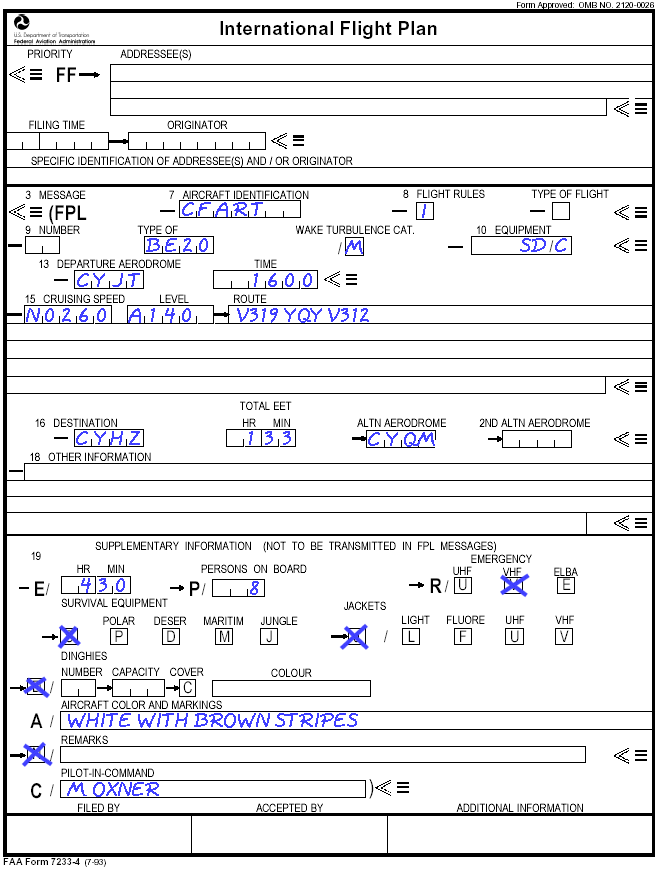
Aviation Topic of the Week
By Michael Oxner, January 25, 2004


Introduction
Previous Week's Topic
Following Week's Topic
Aviation in Canada Blog
Archives

This week's topic:
IFR Flight Example, Part 1: Preflight

In the past, the various stages of flight under Instrument Flight Rules have been discussed at least to some extent. In the coming weeks, I'll take a theoretical flight and walk through an example, from planning to obtaining IFR clearance through to landing. I'll refrain from including operating information specific to aircraft types, like start up and shutdown. Please note that all Weather reports and forecasts, NOTAMs, and everything else held within this page is fictitious and is meant for an example, only. Real-world, real-time data should be consulted before any real-world flight. Now that I've said that, let's get out some charts.

Flight Plan Information
Weather Briefing
NOTAMs
Route of Flight
Flight Plan as Filed

Flight Plan Information

The sample flight will be a Beech 200 Super KingAir departing Stephenville, NL (CYJT) for Halifax International, NS (CYHZ). This aircraft is a corporate aircraft transporting the company bigwigs and some lawyers from an important business meeting in Stephenville home to Nova Scotia. They want to leave around 1600z, which equates to 12:30pm local time in Newfoundland. The RNAV is broken, so navigation will be the old fashioned way, on airways. The aircraft is capable of making the flight at a wide range of altitudes as loaded, so the task is to determine the best combination of altitude for fuel burn and speed, which means considering the winds and temperatures aloft.

Weather Briefing

To determine the cruising level, the weather forecast is consulted, and this includes the upper level wind forecasts for our route of flight. Since we're looking at traveling between CYJT and CYHZ, it is reasonable to consult data for CYJT, CYQY (Sydney, NS, about half way between), and CYHZ. The data found for CYJT appears as in the following example, while similar information for Sydney and Halifax should also be considered..

STEPHENVILLE. NFLD STN YJT
for use
3000
6000
9000
12000
18000
FDCN01 CWAO FCST BASED ON 251200 DATA VALID 251200
08-15
2212
2125-17
2028-20
2138-25
2275-30
FDCN02 CWAO FCST BASED ON 251200 DATA VALID 251800
15-22
1916
2225-15
2228-20
2238-23
2172-30
FDCN03 CWAO FCST BASED ON 251200 DATA VALID 260000
22-06
1642
1938-10
2226-15
2340-21
2274-35


STEPHENVILLE. NFLD STN YJT for use
24000
30000
34000
39000
45000
53000
FDCN1 KWBC DATA BASED ON 230000Z VALID 251200Z
0800-1500Z
2482-41
248556
740658
249651
238850
233153
FDCN2 KWBC DATA BASED ON 230000Z VALID 251800Z
1500-2200Z
2288-42
228157
730358
224650
226550
223352
FDCN3 KWBC DATA BASED ON 230000Z VALID 260000Z
2200-0600Z
2087-41
209256
209754
208049
216749
213551

These indicate the wind direction by the first two digits in each column, then the forecast speed in knots. For forecast winds above 99 knots, 50 is added to the direction group and 100 subtracted from the speed group. That is, winds 270 true at 165 knots would be coded as 7750 (27+50=77, then 65 indicating the two digits to add 100 to). This grouping method will only cover speeds up to 199 knots. The 99 with 50 added to the direction indicates "wind speed 199 knots or greater". The temperature expected at the level is then indicated by either a + or a -, followed by the two digit value in Celsius degrees, with temperatures above 24,000 feet always being considered negative (hence the lack of a "minus" sign in the high level wind chart). Generally speaking, interpolations can be made to determine estimates for levels in between those provided. It is from this method that the planned level of 14,000 feet is chosen, to give the best compromise between true airspeed, fuel burn and wind speed. Given the wind forecast above, the wind speeds listed at 18,000 and above are all rather high. The last listed level at which the winds are relatively weak is 12,000, so 14,000 is chosen as a starting point in hopes that the winds are still near the 12,000 value, rather than rapidly increasing to the 18,000 foot value. Another thing to consider with high degrees of wind speed changes is the possibility of turbulence, including Clear Air Turbulence (CAT).

In addition to the weather data for upper level winds, the weather forecasts for the various aerodromes involved are checked. Since the flight is IFR, an alternate aerodrome is chosen. For this flight, Moncton, NB (CYQM), is chosen as the first candidate to research, since it is known the weather there is often good, the facilities are more than adequate, and the airport is relatively close. St. John's FIC, the Flight Information Center responsible for the area in which CYJT lies, gives us the following information about CYJT when we call them by phone while still planning the flight:

METAR CYJT 251300Z 17006KT 15SM FEW018 BKN030 OVC050 M03/M06 A2983
RMK SC2SC5SC2 OCNL -SHSN SLP103=
 
METAR CYJT 251400Z 17005KT 15SM FEW018 BKN034 OVC050 M03/M07 A2982
RMK SC2SC5SC2 SLP100=
 
METAR CYJT 251500Z 11005KT 15SM FEW016 BKN032 OVC050 M04/M07 A2981
RMK SC2SC5SC2 SLP096=

TAF CYJT 251343Z 251224 17006KT P6SM FEW015 BKN030 OVC050
BECMG 1416 12015G25KT SCT020 BKN030
FM1700Z 12020G30KT 1/2SM -SN BLSN VV007
FM22
00Z 14015G25KT 1SM -SN OVC008
RMK NXT FCST BY 18Z=
 
This could be a topic in itself, couldn't it? Stay tuned for that one. Here we see the last three actual weather sequences (METAR format) for CYJT, and the Terminal Area Forecast (TAF). Basically, the weather at CYJT indicates that it is currently VFR, but forecast to worsen not long after our planned departure time. 1/2 mile in snow, huh? Good time to get out of here! Similar summaries are available for CYHZ, and data should also be considered for CYQM, the chosen alternate aerodrome, to ensure that it is suitable.

While giving us all the requested information, St. John's Radio advises there are no significant weather bulletins (SIGMETs) for our route of flight, but there is a PIREP. A Dash 8 reported moderate turbulence and light mixed icing in cloud at 16,000, 45 NM west of YQY only minutes before our call to the FIC.

The forecast for CYHZ calls for a ceiling of 400 feet, a visibility of 1 SM in light snow, and stiff winds (15-25 kts) from the southwest from two hours before our ETA based on proposed time of departure, until 3 hours after. This doesn't only mean dirty weather when we get there, but it may also have an effect on runway surface conditions at CYHZ, since the snow is expected to start before we even depart CYJT. CYQM's weather is forecast to be 100 broken with no precipitation around our ETA, with ceiling dropping slowly throughout the forecast period until snow is expected to hit Moncton this evening. This makes the Greater Moncton International Airport a good choice for an alternate.

NOTAMs

NOTAMs are checked to find out if any equipment unserviceabilities or anything else exists that may affect our flight. These include at least the following list:
  1. The Headquarters NOTAM section (CYHQ), which applies nationally
  2. The departure aerodrome (CYJT)
  3. The Gander FIR (CZQX) where the flight originates
  4. The Moncton FIR (CZQM) where the flight terminates
  5. The destination aerodrome (CYHZ)
  6. The alternate aerodrome (CYQM)
And here is what we find:

040012 CZQM MONCTON FIR
  CYR- 739 740 743 AND 744 ACTIVE MAX ALT FL300
0401251300 TIL 0401250359

040013 CZQM MONCTON FIR
  SYDNEY RADAR SSD MAINT 0401251500 TIL 0401252100
DELAYS MAY BE ANTICIPATED OPERATING VICINITY CYQY

040017 CYQM GREATER MONCTON INTL
  CYQM ILS RWY 06 109.7 U/S MAINT 0401251200 TIL 0401272000


The date groups are ten digits, starting with the last two digits of the year, the two-digit month, two-digit day, and four-digit time group. The term "SSD" refers to scheduled shut down. "U/S" stands for unserviceable, and "MAINT" is obviously for maintenance.

If the flight were to traverse other FIRs along the way, the NOTAM files would be considered for those FIRs as well. No NOTAMs are found for either departure or destination aerodromes, or the Gander FIR. No pertinent national NOTAMs are found, either. The Moncton FIR is advertising the Sydney radar is out of service from about 1 hour before our flight, with the outage lasting until well after the flight. This may have an effect on the flight, but it may not. The chosen alternate, CYQM, is advertising that the ILS to runway 06 is unserviceable for maintenance for two days commencing today. The weather forecast is expected to be well above VFR conditions, so that is not a factor in the suitability of CYQM as an alternate. Especially considering the availability of the other ILS.

Route of Flight

Now that the cruising altitude is determined, the appropriate IFR enroute charts are selected and reviewed for a suitable route. This entire flight is covered by LO8. There are airways with MEAs below the planned altitude, which ensures adequate signal coverage for the entire flight. The first leg is from YJT to YQY on V319, then on to YHZ on V312. The distances to be flown are calculated, and are plotted on the chart as distances between "compulsory reporting points". Along this route, the YJT VOR is one, the others are UMETI, YQY VOR and COPAR, before finally reaching the YHZ VOR. The total distance is (YJT-UMETI=65, UMETI-YQY=92, YQY-COPAR=92, COPAR-YHZ=67) 316 NM, which is well within the capabilities of the BE-200 at the proposed altitude. The only areas of restricted airspace along the route of flight are south of YHZ and are not expected to come into play even though they are NOTAMed active.

Flight Plan as Filed

In the end, the flight plan looks something like this:
FP Form

As you can see, the Estimated Time Enroute was calculated to be 1 hour and 33 minutes (also written as 1+33) based on the planned true airspeed (260 KTAS), the wind direction and speed from the forecast (calculations expecting a headwind component of 40 knots), and the distance involved (316 NM) , plus some time for the climb and the approach. The way the load for the aircraft was put together, it was determined that the amount of fuel was sufficient for approximately 4 hours and 30 minutes of flight, total time, so that is entered in the boxes following "E/", which is the abbreviation for "endurance". Note that the sample flight plan sheet above is not necessarily the one that would be used, since the sheet shown is actually for international ICAO flights, not those operating entirely in Canadian airspace. This is simply meant as an example.


There's a lot of information covered here, and a bunch more to come. The sample wind forecasts, METAR and TAF for CYJT were obtained and modified for this example from NavCanada's Aviation Weather Web Site (AWWS) which can be reached following this link. NOTAMs are also accessible here, and the examples presented in this situation are fictitious, but based on reality. Anything to add to the pre-flight stages? Find anything untoward? Drop me a line at my e-mail address, moxner@nbnet.nb.ca. Thanks for taking the time to read, and especially to those taking the time to write!