|
|
|
|
|
Once again, I feel silly doing it, but I also feel like I have to
do it. This week's topic contains clips from outdated charts and these
are meant only as reference for the examples. While much of the data hasn't
changed since publication, I don't know how much actually has. As always,
refer to current, real-world publications for real-world flight.
That being said, let's continue on.
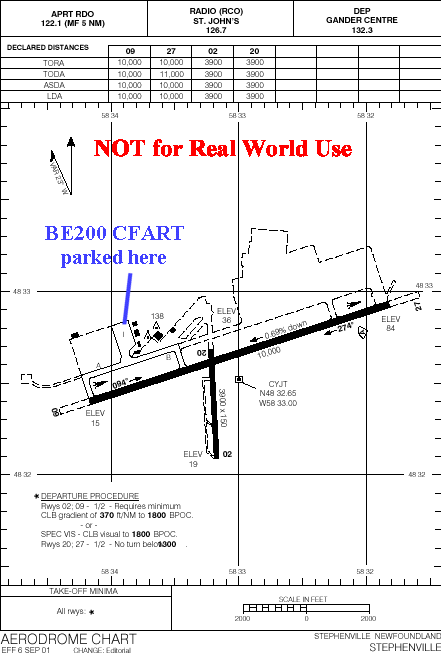 There are three communications agencies listed across the top of the
aerodrome chart, none of which are CLNC DEL or GND. The first one is "APRT
RDO", and they are not an approved agency for relaying IFR clearances. They
operate the station at the field and provide airport advisory, only. Things
like winds, altimeter and known airport conditions are relayed by such
a station. They do not provide a control service, nor do they normally converse
with ATC.
There are three communications agencies listed across the top of the
aerodrome chart, none of which are CLNC DEL or GND. The first one is "APRT
RDO", and they are not an approved agency for relaying IFR clearances. They
operate the station at the field and provide airport advisory, only. Things
like winds, altimeter and known airport conditions are relayed by such
a station. They do not provide a control service, nor do they normally converse
with ATC.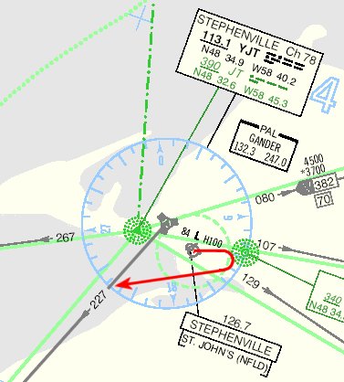 Another issue when evaluating and interpreting an IFR clearance as
issued above is the departure instructions. Do they make sense? The image
at right comes from an outdated copy of LO8 and is used as a reference
to determine where V319 is in relation to the airport and whether the departure
instructions will actually get the aircraft to the airway at an appropriate
spot. It is also important to review the take-off minima on the airport
diagram in the CAP to see if there are any special departure procedures
or if a standard departure profile will work. These have been discussed
in past topics, so the Archives can be
consulted if there is any question about what these are.
Another issue when evaluating and interpreting an IFR clearance as
issued above is the departure instructions. Do they make sense? The image
at right comes from an outdated copy of LO8 and is used as a reference
to determine where V319 is in relation to the airport and whether the departure
instructions will actually get the aircraft to the airway at an appropriate
spot. It is also important to review the take-off minima on the airport
diagram in the CAP to see if there are any special departure procedures
or if a standard departure profile will work. These have been discussed
in past topics, so the Archives can be
consulted if there is any question about what these are.