|
|
|
|
|
This week's topic:
Canada Air Pilot, Part 3: STARs
Finally I believe we have talked enough about NAVAIDs and approaches to allow us to move to the final topic before we return to the IFR Flight series. We'll continue one more step with the Canada Air Pilot (CAP) series to allow some insight into the publication end of flying STARs, including the now popular PBN STARs (formerly known as RNAV STARs and FMS STARs before that). The bulk of this information can be found in Canada's Aeronautical Information Manual, section RAC 9.2
Note that there have been many changes in design, criteria, and procedures associated with STARs in the 20 years since this original article was written. As such, this one nearly required a total rewrite. Let's dig in!STAR Definition
Types of STARs
Intent of the Chart
Flight Planning and STARs
Naming of STARs
STAR Routes to the Runways
Closed Routes
Open Routes
Altitude and Speed Restrictions
Altitude and Speed Assignments by ATC
Anatomy of a STAR Chart
Frequency Boxes
Available Transitions
STAR Notes
Waypoints, Fly-By and Fly-Over
Runway Determination
Shortcuts and Other Descent Issues
STAR is short for Standard Terminal Arrival Route. STARs are usually established around busier airports and serve two parallel purposes: From ATC's presepctive, STARs provide a predictable path for arrivals to help organize IFR aircraft when sequencing them for approaches. From a pilot's perspective (or from that of an aircraft operator like an airline), the STARs also provide a more predictable routing than aircraft approaching from random directions and having to be vectored over the sky during sequencing. This allows the pilot to conduct a more optimum descent profile, saving fuel in the process. Also, since the procedure is published, ATC may refer to the procedure by name rather than specifying individual fixes in much the same way an Instrument Approach Procedure (IAP) is referred to by name instead of specifying courses and altitudes.
A well-designed STAR allows for smooth integration of traffic, as well as providing a pilot with all the required information in terms of routings and altitudes. These atltitudes come in two slightly different "flavours": One is meant as a minimum altitude meant to clear obstacles and terrain, similar to an MEA on an airway, and these are generally applicable for a particular segment between fixes on the STAR. Others may be published in the form of altitude restrictions and these are generally related to other air traffic. These may be published as an "at or above" or "at or below" altitude, or maybe as a "hard altitude", meaning the aircraft must be at that particular altitude. The "at or above" and "at or below" altitudes may be published giving a pilot a "window" of altitudes to fly at a given point.
Some STARs are based on conventional NAVAIDs like VORs (though RNAV-equipped aircraft may still fly them wihtout specifically tuning the underlying ground-based NAVAIDs). These are being gradually replaced by RNAV-based STARs. Originally called FMS Arrivals, these were renamed as RNAV STARs and the name is changing again. Performance-Based Navigation (PBN) is the new buzzphrase for them. Briefly, PBN refers to a specification of minimum navigation performance required for a particular procedure or airspace rather than requiring specific navigation equipment to for that procedure/airspace. That said, they are labeled "STAR (RNAV)", to indicate what they are, so it seems a little confusing. The PBN navigation specification (NAV SPEC) is noted in the PBN box on the STAR's chart in the CAP.
STARs may have one or more entry points, called "transitions", that take an IFR aircraft from the enroute phase of flight to the arrival phase. In the case where a STAR contains more than one transition, the transitions will be noted on the chart. ATC may, if traffic warrants, take an aircraft off a transition and re-clear the aircraft for the same STAR via another transition. Given the "heads down" time required, ATC will not normally do this as it is understood that this takes time and attention, and also may alter the distance to be flown, thereby affecting the descent planning and the "Top of Descent" (ToD).
Like a SID plate, the STAR plate is meant to be used as a reference for navigation while flying the STAR. Prior to reaching the beginning fix, also known as the "STAR entry point", the pilot is meant to put away the en route navigation charts and use this plate for navigation. There are all kinds of information deemed essential for this purpose printed here, such as navigation facilities and their frequencies, VOR radials and NDB tracks associated with the arrival route (for conventional STARs), Minimum IFR Altitudes for depicted segments, Fixes, altitude/speed restrictions, etc. Additionally, as detailed below, there are other bits of information such as instructions for communication failure and procedures to be followed and other information regarding the procedures. More information will follow below.
For STARs, the pilots are required to file them in their flight plan if they intend to fly them. Many airports where STARs exist also have published "Mandatory Routes" meaning the pilots are supposed to file and fly these routes between specified points of departure and the destination. If the mandatory route includes a STAR, so should the flight plan. The IFR clearance a pilot receives from ATC on departure should include either the term "flight planned route" or a detailed clearance which includes the STAR to be flown as part of the route. Right from the ground, the pilot has authorization to fly the STAR. The only required detail that is not generally known on departure is the runway to be used at the destination. That part is discussed below. If all or any part of the STAR can't be accepted, it is the pilot's responsibility to refuse the clearance and ask for alternative instructions.
Pilots and flight planners should refrain from putting STAR waypoints in succession in their flight plans. Instead, simply include the STAR name and validity number (discussed below) in the flight plan. Also, flight planning the runway number prior to departure can be a mistake -- if the weather at the destination changes during flight, the FMS will require updating to ensure the proper flight path and the proper determination of the location of the Top of Descent (ToD).
The standard convention for naming STARs is to use a fix associated with it, along with the spoken name, the type of STAR and a "validity number". In smaller text above the name, the type will be identified as "STAR" for a conventional STAR and "STAR (RNAV)" for a PBN STAR based on RNAV. Beneath this name will be the plain-language name of the STAR as it should be referred to on the radio, the validity number and the term "ARR" indicating an arrival. Hence, the "STAR (RNAV) FUNDY FOUR ARR" shows it's a PBN STAR and should be referred to as the "FUNDY Four Arrival" -- the word "STAR" is not spoken, just the same as with the word "SID" is not spoken when referring to a Standard Instrument Departure.
Also like SIDs, STAR validity numbers are advanced when information on the chart is altered or updated. This ensures that a pilot has the current information. If ATC clears a pilot for the "FUNDY FOUR Arrival" but the pilot only sees the FUNDY3 arrival in the FMC or the charts, there may have been an important change to the information on the STAR and ATC should be queried as to what to do. Similarly, if the pilot reads back an incorrect number, the controller should be alert to the fact that the pilot may not fly the correct path, depending on the changes since the previous number.
Since the purpose of a STAR is to transition an aircraft from the enroute phase of flight to the arrival phase, it follows that the STAR paths should join to the Instrument Approach Procedures (IAP) at the destination airport. Just how and where they join depend, to an extent, on the approach type but also the runway itself and the course the aircraft is to be aligned with. As such, there are two types of STAR paths to be considered: The "Closed" path and the "Open" path.
For a "Closed route", the pilot is allowed to complete the route as depicted and join the final approach course. Again, bear in mind that speed and altitude restrictions are published and must be adhered to unless otherwise authorized by ATC. The reasons are two-fold: First, the aircraft's speed must be constrained to ensure adherance to the approach path, and second, they help set expecations from one aircraft to another for ATC in the same way that a terminal/appraoch controller assigns speeds to aircraft when sequencing them to make consistent and predictable flight paths.
Closed routes are most often used for runways where the inbound track of the STAR is close to the final approach course thereby not allowing much room for an aircraft to make turns to downwind or base legs, essentially on straight-in paths to the runway from the STAR. That said, a closed route may be designed into a STAR that even makes a 180 degree course reversal, allowing the aircraft to fly all the way to the runway without further intervention.
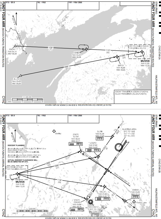
"Open routes" in RNAV STARs are used where ATC expects a requirement for most aircraft to be vectored for sequencing. The STAR path will essentially end at a given fix with instructions for pilots to fly the depicted heading (which is often, but not always, straight ahead). The ending fix is normally one associated with one or more approach procedures. In the case of the FUNDY4 Arrival above, DUTIR is the end point (Downwind Termination Waypoint or DTW) on the STAR path for Runway 23 and DUTIR is also used as an Initial Approach Waypoint (IAWP) on the ILS, ILS CAT II, and RNAV (GNSS) Z approaches for runway 23.
If traffic is light, ATC may not have a requirement to vector the aircraft after the DTW. A controller may issue an approach clearance before the aircraft reaches the DTW (2-3 NM is recommended as a minimum to give the pilot time to set the FMC and to ensure the FMC does capture the proper path to make the turn required). Once that approach clearance is issued and readback by the pilot, the pilot may delete this "vector leg" which normally shows up a "discontinuity" ("DISCO" or other similar abbreviation), joining DUTIR on the STAR to DUTIR on the approach, allowing the aircraft to make the turn.
Altitude and Speed Restrictions
Pilots must be alert to the speed and altitude restrictions published on the STAR and on the IAP to be flown after the STAR to ensure all are met. These are normally included in the coding of the procedure in an FMS, but pilots should verfiy they exist in the displays to match the STAR chart. Pilots may ask ATC for any published restrictions to be cancelled, and ATC may cancel restrictions without a request from the pilot. Pilots must use caution with speed restrictions in particular, since these are often published to ensure the aircraft doesn't overshoot the tracks between fixes, especially where turns to base leg or final occur.
As stated earlier, when ATC clears an aircraft for an approach, the pilot may enable the approach on the FMC. Even with the receipt of the approach clearance, any and all altitude and speed restrictions published on both the STAR and the IAP must be followed unless specifically cancelled by ATC.
Altitude and Speed Assignments by ATC
While it's all good to know that there are altitudes and speeds published on various segments of the STAR, pilots must be aware that they are not permitted to descend simply because the FMC reports reaching Top of Descent (ToD). A clearance must be issued by a controller before an IFR aircraft may commence descent. Further, if an initial descent has been commenced, that last assigned altitude is the lowest the aircraft can descend until in receipt of a lower one by the controller.
This all seems pretty straight-forward until the question comes up about a published altitude restriction the aircraft is still above. For example, if the aircraft is only cleared to 8,000 but there is a restriction at a waypoint ahead that says, "at 5,000". What should the pilot do? If ATC hasn't volunteered a lower altitude, the pilot should maintain the last assigned altitude (8,000 in this case) and ask the controller. The controller may have forgotten or may have other traffic ahead and may have to change the initial plan.
Similarly, when speed restrictions are published, they must be met until and unless ATC supercedes them with new instructions or cancels them outright.
One more note about altitude assignments: If ATC assigns the aircraft an altitude below that of a waypoint still ahead of the aircraft, the aircraft must still meet that altitude restriction. Take, for example, an aircraft descending through 12,500 and there is an altitude restriction of 10,000 at the next waypoint. If ATC then clears the aircraft to descend to 8,000, the aircraft must still cross that next waypoint at the published 10,000 feet before descending further to 8,000. Most FMC will do this automatically, but a pilot should still monitor the progress to ensure restrictions are met.
Below is an example of a PBN STAR. This is the outdated chart for the FUNDY4 Arrival at CYHZ. Let's walk through the various parts of this.
STARs will normally have charts that show the transitions (entry points) and the routing to be flown from those waypoints to the point where the STAR paths diverge to the various runways at the airport. Often, the area being depicted would be too large or too cluttered to be published on one page, so these are often split between two, as the FUNDY4 example.
The transitions take the aircraft from the enroute portion of the flight to the arrival portion. These routes may be short or long, and may have several waypoints along the route. Holds may be published on the routes, as well, which are convenient. In the event that traffic must be held, the phrase "hold as published" may be used in lieu of describing the hold in a clearance issued to the pilot which would require a full readback by the pilot, tying up precious radio time. Holds may be required at these points due to traffic, weather-related issues, etc.
Once it is known which runway will be used, the pilot must program the FMC to set the aircraft up for the desired runway and instrument approach procedure. The active runway is broadcast on an ATIS, where available, but the controller must inform the aircraft of the runway to be used even if an ATIS is broadcasting. Of course, if the pilot wishes to use another runway, the request may be made to the controller, who should then base the approval on existing traffic and other conditions (real-world pilots have to contend with runay surface conditions, NOTAMs regarding runway availability, etc, but the Flight Simulation world generally doesn't have to worry that much about this sort of thing). The second page of the STAR example above shows the fix MUVOX is the point where the aircraft will alter course to set up for the desired runway.
Referring back to the FUNDY4 Arrival above, there are many little boxes with information around this plate, as there are with most STARs. Beginning with the top left, there is a list of frequencies to be used while using this chart. They are arranged in the logical progression that a pilot is expected to use them while on approach. If the airport is equipped with an ATIS, this is listed first, then the Terminal/Arrival controller's frequencies, then Tower and Ground.
On the bottom of the STAR's first page, a box contains the available STAR transitions. As mentioned above, they are named by the entry fix, a period, and the name/number of the STAR. You can see in this example, there is a transition from EBONY (EBONY/FUNDY4) and another from ALLEX (ALLEX.FUNDY4). The pilot would determine which entry point is appropriate and program this as part of the flight plan. Which one is approriate may be decided based on the direction from which the aircraft is approaching (a more northern inbound course would be better off making use of the EBONY transition rather than flying a few extra miles south to use the ALLEX transition, for example). Alternatively, Mandatory Routes may be published by ATC asking aircraft approaching from certain directions to use a specific transition. These Mandatory Routes can be found in the Flight Planning section of the Canada Flight Supplement (CFS).
Often, STARs have notes associated with them. In this case, there are notes regarding certain altitude restrictions that are published on the FUNDY4 Arrival. At this airport, there are RNAV (RNP) approaches published that are "connected" to the STARs, and these approaches have mandatory altitudes (5,000 feet in these cases). Aircraft planning to fly the RNAV (RNP) approaches must meet these restrictions. Given that these approaches save the aircraft upwards of 12 NM of flight, pushing an aircraft down to this altitude if it is not going to fly these (any of the ILS, or RNAV Z approaches with the typical "T" design) means that the efficiency of the STAR is somewhat lost by having the aircraft too low too early. Notes are therefore added to this particular STAR stating that the "at 5,000" foot altitudes at fixes EBLUV for Runway 32 and LOGPO for Runway 23 do not apply and therefore pilots may delete the altitude restrictions at those waypoints if the RNAV (RNP) will not be flown. Notice that the note only makes reference to the altitude restriction at these fixes: The speed restriction still applies so the pilot must still adhere to the speed restriction unless otherwise authorized by ATC.
Other notes may be placed on this chart that change the interpretation of the STAR instructions as required.
Waypoints, Fly-By and Fly-Over
Several symbol types are published on STARs, and the main two are Fly-By and Fly Over. The sybmols are drawn very similar, but the points on the Fly-Over are shaded black, but left unshaded on the Fly-By. For a Fly-Over waypoint the aircraft is required to fly over the waypoint before commencing a turn. The Fly-By waypoints allow RNAV-capable aircraftto conduct a "smart turn". The FMS will gauge wind speed and direction along with aircraft speed and commence the turn prior to reaching the fix so as to make a smooth, single-turn transition from the previous track to the next track without going beyond the fix or beyond the next track segment. Normally, most waypoints on a STAR are designated as fly-by since it is more important for the aircraft to be aligned on the designated tracks between them rather than having them go over the waypoint itself.
While conventional STARs are largely being replaced by PBN STARs, some still exist. These STARs are based on traditional, ground-based NAVAIDs and provide courses/radials to be flown from VORs and, rarely, NDBs. RNAV-equipped aircraft may still fly them and are not required to tune in and fly the underlying NAVAID to do so. Such STARs will have similar depictions in plan view to the PBN STARs discussed above, and may include speed and altitude restrictions published at various points along the route. The naming conventions are all applicable as described above, as well. These are being mentioned here without detail since they are becoming fewer and further between, and will likely be phased out entirely over time.
Pilots should not program the arrival runway at the destination airport into the FMS until within range of the destination. Weather changes can occur, as can traffic patterns, requiring a resetting of the FMS programming. Pilots should be prepared for this possibility in flight, regardless of the timing.
If the destination is served by an ATIS, the pilots should receive the current ATIS message (not use the old one that may have been picked up prior to departure) as soon as they are in range for receipt. Regardless of whether an ATIS is broadcasting, the arrival controller is required to inform the pilot of the runway to be used on initial contact. In many areas, initial descent will be issued by an enroute controller instead of the terminal/arrival controller. If a runway other than that mentioned on the ATIS is desired, the pilot need only ask. Use of the runway will normally be approved or denied on the basis of current or anticipated IFR traffic or other conditions.
In any case, the pilot must confirm the route is programmed into the FMS properly before beginning descent, if possible, to ensure the best application of descent profile.
Shortcuts and Other Descent Issues
Sometimes when looking to solve a traffic conflict, a controller may look to cut a corner and send an aircraft directly to a waypoint further along the STAR than the aircraft is currnetly tracking. Controllers should be alert to the issues faced by pilots when doing this. If, for example, cutting a fix out of the route shortens the path by 10 NM, the aircraft's FMS will have to recalculate the descent path. If descent has already begun, the aircraft is very likely to be several thousand feet to high, requiring management of speed and descent with the use of speed brakes. A pilot may be in a position where the aircraft is too high to continue the path to the Instrument Approach Procedure (IAP) from its current position.
Other times, traffic may prevent issuing a descent clearance when an aircraft is reaching its planned ToD. If this happens, the aircraft may be in a position where it is higher than desired, possibly even beyond the point where speed brakes can be effective enough to get the aircraft down in time. Alternatively, a controller may "push an aircraft down" early, leading to a "flatter" descent than initially planned. Perhaps speed control is required due to other traffic. In all of these cases, pilots may have to manually adjust the descent profile.
Another complicating factor for an FMS is vectors. When traffic dictates ATC intervention in sequencing with vectors, the FMS is no longer able to predict the distance to the runway and as a result, cannot adquately determine an optimum descent rate. Pilots should be alert to this possibility and be familiar with how their systems react to such issues and know how to adjust them, as required.
Well, that's the charts end of the STAR. In the next topic, I will review the PBN STAR from the ATC and pilot side of things with some phraseology examples. Any feedback on this week's topic can be sent to me via e-mail at mo@xlii.ca. Thanks!