Aviation Topic of the Week
By Michael
Oxner, June 13, 2004
This week's topic:
More on Cold Weather Altimeter Errors
What would possess me to write on this topic in June? How about
the ruddy spring weather that hardly broke the 20's so far this month and
last month? Someone asked about why cold weather requires correction factors
and warmer weather doesn't, and I found a logical answer some time ago. With
warmer weather on our doorstep (hopefully), it is a little more timely than
it initially seems.
Review of ICAO Standard Atmosphere
Warm Weather Effects
Cold Weather Effects
Compare the Three Situations
Review of ICAO Standard Atmosphere
 The pressure altimeter used in aircraft is calibrated to read altitude
based on measurements of barometric pressure. Because of the number of variables
in air which can affect barometric readings, a baseline model had to be
developed so we could determine the amount of deviation. The ICAO Standard
Atmosphere has a number of conditions attached to it. Included are the following
factors:
The pressure altimeter used in aircraft is calibrated to read altitude
based on measurements of barometric pressure. Because of the number of variables
in air which can affect barometric readings, a baseline model had to be
developed so we could determine the amount of deviation. The ICAO Standard
Atmosphere has a number of conditions attached to it. Included are the following
factors:
- The temperature at sea level is 15° Celsius
- Temperature drops at a rate of 1.98 C° per thousand feet until
the height where it reaches -56.5°C and then remains constant
- Barometric pressure at sea level is 29.92 inHg
- The air is a perfectly dry gas
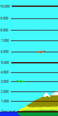
It is a reasonable analogy to compare the pressure levels (which would
be indicated as altitudes on an altimeter) to the markings on a ruler stood
on its edge. Each mark on the ruler could be said to represent 1,000 feet,
for our purposes. Have a look at the diagram at right and see what I mean.
The green aircraft is indicating 3,000 feet, and actually flying at 3,000
feet. Similarly, the red aircraft is also flying and indicating 6,000 on his
altimeter.
 Warm Weather Effects
In warmer air, the chart above changes a little, as the pressure
levels will actually expand. This means there is more actual distance between
the pressure levels than there is when it is warmer. it's as if the ruler
still has the same number of marks on it, but it has stretched so its top
still meets the top of the column of air, and its bottom is still at sea
level. Have a look at the diagram to the right to see the effects of warmer
than standard conditions.
The warmer conditions mean that an aircraft indicating 4,000
feet on his properly calibrated altimeter that is set to a proper altimeter
setting may actually be flying at 4,200 feet -- higher than the pilot believes
he is. This isn't too much of an issue, since the hills don't climb with
temperature, and all the other pilots in the area would experience, in theory,
the same amount of error. It also means that the pilot indicating 5,000 feet
might actually be flying at 5,230 feet. The higher the altitude, the more
the error. Thus, an aircraft may have more difficulty reaching its service
ceiling on its altimeter on a hotter than standard day. It may very well be
at that altitude, but its altimeter would actually read lower.
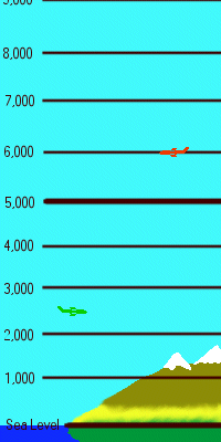
The diagram to the right shows the same two aircraft from
the above diagram. The green aircraft is at the same height above sea level
as he was in the previous diagram, but now he is indicating 2,500 feet instead
of 3,000. The red aircraft, on the other hand, is flying an indicated altitude
of 6,000 feet. He is actually higher than this, as evidenced by his increased
distance above sea level. To emphasize this effect, I've placed these two
diagrams, along with the third from the next section, in a table at the
bottom of this page.
 Cold Weather Effects
Now we get to the other end of the scale, where the effects
are a little more dangerous. In a similar fashion to the way warmer air expands
the ruler, colder air shrinks it. Again we still have the same number of
marks on the ruler, but the overall length of the ruler, representing the
top of the atmosphere and sea level, is actually shorter. This means that
an aircraft indicating 3,000 feet may actually be flying only at 2,800 feet.
Similarly, an aircraft indicating 10,000 feet would be somewhere closer to
9,200 feet. Remember, the altimeters when set to local station pressure would
still indicate higher altitude. Thus, in order to ensure the plane is flown
at the required altitude, like a minimum segment altitude for an approach,
the pilot would have to calculate the altitude correction factor and add
it. Therefore, with the situation above at 3,000 feet, the pilot would have
to add the 200 feet, and make the altimeter read 3,200 to ensure he meets
the obstacle clearance altitude of 3,000.
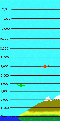
In the diagram at right, once again the green aircraft is
at the same actual elevation above sea level, which is, as it has been,
3,000 feet. With a colder than standard atmosphere, he is now indicating
about 3,800 on his altimeter. The more likely situation is the red aircraft,
however. He is diligently flying his 6,000 feet on his altimeter, indicated
once again by the pressure level lines on the diagram. If you look at the
comparison below with the three diagrams side-by-side, you'll see that he's
actually lower than he was in the other two diagrams, despite paying particular
attention to the gauge. This is why cold weather altimeter correction factors
must be applied.
Compare the Three Situations
As promised, here they are, side by side. Remember, the green
aircraft is always at the same actual level, while the red aircraft
is always at the same pressure level, which corresponds to indicated
altitude. In all three situations, station pressure at sea level is the
same setting, while the temperature in each diagram is vastly different
form the ICAO Standard Atmospheric Model. While you're comparing diagrams,
compare the vertical distances between pressure levels, and the number of
pressure levels visible in each image. All three images are the same dimensions.
Warmer than Standard
|
ICAO Standard
|
Colder than Standard
|
|
|
|
This is, perhaps, a simplistic overview of it, but it may
be more than we really need to get into for this topic. Remember to add
corrections as required (discussed
in the first topic of 2004), to ensure adequate obstacle clearance, and
only where required. Any thoughts? Send me an e-mail at moxner@nbnet.nb.ca.
Thanks again for reading and writing!