Aviation Topic of the Week
By Michael Oxner, August 31, 2003


Introduction
Previous Week's Topic
Following Week's Topic
Aviation in Canada Blog
Archives

This week's topic:
Aircraft on Radar Vectors

Many questions have been sent to me regarding radar vectors with questions coming from both sides of the ATC radio. What should I do as ATC? What can a pilot expect? Some of these have been answered, or partially answered, in past topics, but we'll have another look at them this week.

Definition of a Radar Vector
Purpose of Radar Vectors
Requirements for Vectoring
    Minimum Radar Vectoring Altitude
Basics of Vectoring
    Commencing a Vector
    Terminating a Vector
Vectoring for an Approach
    Where to Vector an Aircraft
    Honing Vectoring Skills
Speed Control
What a Pilot Should Do on Vectors
    Communication Failure on a Vector
    VFR Aircraft on Vectors

Definition of a Radar Vector

Once again, our trusty AIP is the reference for this one. It simply says a vector is, "A heading issued to an aircraft to provide navigation guidance by radar." The ATC Manual of Operations, called MANOPS, says:

VECTOR —
A. A heading issued to an aircraft, for the
purpose of providing navigational guidance
by means of radar.
B. To issue headings to an aircraft, for the
purpose of providing navigational guidance
by means of radar.


Same definition, but one meant as a noun and the other meant as a verb.

To vector an aircraft, you simply tell him the heading you wish him to fly. In Canada, our radars are oriented on magnetic north. Fortunately, the VatSim world has the same convention, though I understand this is not necessarily the case everywhere. This makes it simple. If you want the aircraft to fly straight up on your screen, you tell him to fly heading 360. If you want him to fly east, or to the right hand side, you tell him to fly heading 090. Always express the heading in three digits, and proper radiotelephony for issuing headings is not to "group" the numbers. For example, south is "heading one eight zero," not, "heading one eighty". Remember also that the heading of 090 in no-wind conditions will have the aircraft flying parallel to your desktop, not the center of the right-hand side of your screen unless he happens to be in the center from top to bottom.

Winds come into play while vectoring, too. In a no-wind situation as mentioned above, the heading the aircraft is flying and the track the aircraft is actually travelling will be the same. If you're aircraft on a heading of 090 is flying in a wind that is strong out of the north, he will be blown southward at the same speed of the wind, so, depending on how fast the aircraft is travelling, he may actually track 100, or 095 while flying a heading of 090. Take this exaggerated example:

You're aircraft is cruising at 100 knots true airspeed, and flying heading 090. The winds are out of the north (so travelling south) at 50 knots. I chose these numbers for ease of use. To simplify the numbers above, for every mile the aircraft travels east, he will be blown one half mile south, making a drift of 30 degrees, so a track of 120. The speeds will also work together to provide a groundspeed of around 115 knots.

I won't go into the mathematical reason for the above. The faster the indicated airspeed of the aircraft, the less drift from your heading the aircraft will suffer. Also, the less of a difference between your heading and the wind direction, the lesser the effect of wind drift. 90° is the biggest difference possible between aircraft heading and wind, since a straight headwind or a straight tailwind will not affect the aircraft's track, only its speed.

Purpose of Radar Vectors

The definitions above indicate a vector would be used for radar navigation guidance, but for what purpose? There are several reasons. A vector might be initiated by ATC to get you around restricted airspace, other traffic, or to help you transition from the en route phase of flight to the approach phase if you're IFR. The pilot could also request a radar vector for any number of reasons. In addition to the above reasons, a pilot who becomes disoriented only needs to contact ATC for help. Where equipment permits, radar is the best source of information. It requires nothing more than a transponder (or less if primary radar is available and the aircraft can be seen), so regardless of where the aircraft is or what the pilot thinks he is doing, ATC can tell what's going on. In the case of a PAR or GCA, the radar can be used to give precision approach guidance in bad weather almost right to the ground, and this will require nothing more than a receiver on board the aircraft as a bare minimum, since the rest of the information can be derived totally from the radar antenna. Vectoring is also part of many standard ATC procedures, like radar vectored SIDs, some instrument approach procedures or STARs labeled as "Radar Required", and so forth.

Requirements for Vectoring

First things first, ATC has to have radar that provides coverage of the area concerned. Secondly, ATC must also be able to communicate directly with the aircraft except in certain circumstances (emergency, for example) (MANOPS 501.2). If the aircraft is IFR, it must be at a safe altitude to provide obstacle and terrain clearance (see below for MRVAs). For a VFR aircraft, the aircraft must be in VMC and be able to see to avoid any terrain, obstructions or bad weather. Also, there is a basic premise that the aircraft has to be a willing participant. MANOPS 541.2 gives ATC the flexibility to provide vectors if required, if an operational advantage will be gained by ATC or the aircraft, and for other reasons like noise abatement, for example.

Minimum Radar Vectoring Altitude

MRVAs are established where ATC vectors are initiated or requested frequently. They are often lower than other applicable minimum IFR altitudes because they can be more focused in specific areas rather than general like a 25 NM safe altitude around a final approach fix, for example. As a result, these are not published on any instrument approach procedure, but may coincide with values so published. Since ATC is responsible for obstacle clearance for an aircraft on radar vectors, the MRVA will, by definition, provide for a number of issues like cold weather altimeter errors, terrain and obstructions, restricted airspace, etc. The MANOPS Definition for an MRVA also includes radio coverage, but oddly enough, not radar coverage. It is also supposed to consider the base of controlled airspace in a given area, so the radar vectoring altitudes are often lower in terminal areas where the airspace classification is better designated to include lower transition areas. On this note, ATC may provide vectors to an aircraft in uncontrolled airspace (class G) if requested by the pilot, or if ATC suggests it and the aircraft accepts it.

Basics of Vectoring

There are certain things a controller must consider when vectoring. First, he must have the aircraft radar identified. I wrote a topic on this some time ago, and if you're not sure of the ways this can be done, have a look in the Archives for that topic. Next, is the aircraft at a safe altitude for vectoring if he's IFR, or in good VMC if he's VFR? Can the aircraft be established on a non-radar route (airway, track or approach procedure)? All of these conditions met? Good. Let's vector.

Commencing a Vector

When commencing a radar vector, ATC must inform the aircraft of the reason for the vector, and/or the point to which the aircraft will be vectored. This could include an airway, final approach course, a NAVAID, etc. Here are some examples of phraseology. Terminating a Vector

When you're done vectoring an aircraft, you can't just leave him hanging. MANOPS 547 tells us ATC may terminate a radar vector if the aircraft is cleared for an approach, cleared to hold, or established on a non-radar route. Unless vectoring for an approach, ATC is supposed to tell the aircraft when vectoring is terminated. This is usually a direct statement like, "resume normal navigation" or "proceed on course", for example. To cover the second example, the aircraft is considered on a non-radar route if it is on a track which will intercept the "on course" within a reasonable distance, or if the pilot will navigate visually following the vector. ATC is required to provide an aircraft with a position when terminating vectors, such as when vectoring for an approach (see below). Some examples heard frequently include things like:
Vectoring for an Approach

This is the one where all the pride and glory comes from. A lot of people know about the guys who are stuffing the aircraft in on approaches at the busy airports. Practice makes perfect. To be good at stuffing aircraft in like the pros in Chicago, Atlanta or Halifax (yes, I consider these folks among the best at what they do), you have to see not only a number of aircraft, but you have to see a number of aircraft over a short time. Anyone can vector one aircraft at a time, but it takes a lot of practice to be efficient at vectoring 20 or 30 to the same point as you generate a sequence.

Where to Vector the Aircraft

For many folks, especially a military controller, the term "Radar Square" is quite familiar. The concept is simply to vector the aircraft in a traditional "circuit" pattern, using headings to accomplish track changes of 90° where practical. The aircraft is to be vectored downwind, given a heading that accomplishes a track parallel and opposite to the runway for landing, then given a ~90° turn to accomplish a square base leg, and then the turn to intercept final. Is this a rule? I have never seen it written down. So what are the rules, then? Funny you should ask.

First, you should have already told the aircraft that you intend to vector him for an approach, and which one you plan to send him to. This lets the pilot get out the appropriate approach plate, brief the approach in a multiple crew member environment, etc. If you're not vectoring in a terminal environment, such as an en route sector in an ACC, you also have to specify a clearance limit. The fix used for this should be a fix from which an approach can be carried out, and this is often the final approach fix. If the FAF is not a NAVAID, you should be sure the pilot is capable of finding it (RNAV, GPS, INS, etc, on board the aircraft).

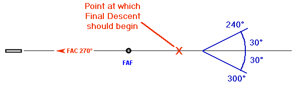
The aircraft should be vectored to intecept the final approach course at a point that is at least 2 NM back from the point at which final descent will begin. To figure out just how far back he has to be, take the MRVA (discussed above) in the approach area, and subtract the field elevation. For a 3° glideslope, the standard value, multiply this number (actually, consider it in 1,000's of feet) by 3 and you'll have roughly how far back the final descent will begin. This is because a 3° glideslope translates to 308 feet per nautical mile. Sound confusing? Try this example:

At Moncton, the MRVA is 1,800 feet. Field elevation is 232 feet. So, we'll round off the 232 to 200. Take 200 off 1,800 to get 1,600 feet. At 300 feet per NM, you can see that final descent will begin at about 5.3 NM from the runway threshold. The runway should be marked on the radar map. So, 2 NM back from that gives you a distance of 7.3 NM. Aim to put the aircraft on the localizer at 8 NM back, and you're right on track.

The next issue is how sharp a turn you can give a guy. On VatSim, I've been given many 90° turns to final, and I have heard worse. The rule is 30° or less. If the final approach course is 270°, a no-wind heading to final from the north would be 240, and form the south would be 300. See the diagram below.

Final Intercept

Of course, with stiff winds and a slow flying aircraft, you may have to steepen it a little. If the reverse of the extreme example above were in effect, the simple heading of 090, which with the wind would give a track of 120, would be a good heading for the intercept from the north. What to give from the south would be a little more complex to calculate mathematically, but relatively easy to figure out by experimenting with headings and seeing the resulting tracks. This is where experience counts. You learn from each successive aircraft you vector what should be a good heading for the next one. From a pilotting point of view, if you are in strong winds, you'd almost be better off being number two or three in the sequence. You may just get a better vector.

Honing Vectoring Skills

Anyone who has vectored aircraft, either in the real world or online, knows that vectoring really isn't a science. I believe so few people are willing to provide direct training on vectoring for that reason. It's something you have to learn with experience. Sure, there are some rules, but to really understand vectoring, you have to do it in varying conditions, with different aircraft, even many aircraft at the same time. Pilots will make turns at different rates, some commence turns later than others, and winds affect aircraft differently depending on speed and direction. This is why it's a good idea to provide yourself with some room to correct for mistakes, be they yours or the pilot's. Vectoring most aircraft about 5 NM from the field on a downwind is usually enough room. This way, you can watch the base leg turn to see how tight he turns and then adjust when you issue the turn to final. In the event the aircraft is basically already established on the base leg, you loose this insight, so you might vector him a little wide to begin with, just in case he makes his turn shallow and flies through. In fact, sometimes you want to make him go through the final approach course for spacing, and you have to advise him if you do intend to let him go through. Some rules of thumb I use when vectoring include these, which happen to work at most of the airports in my home region of Moncton. You'd have to check to make sure the distance works with your altitudes you use, according to the rules mentioned above.
  1. A rough guideline for when to issue the turn to final if your aircraft is on base leg and turning 90° final is roughly 1 NM for each increment of 60 knots groundspeed. If he's grounding 120, issue the turn when he's approximately 2 NM from the desired track. If he's doing 180, stretch it almost to three miles. It doesn't always work, but it's a good place to start if you don't know what to work with.
  2. Aim for a point 10 NM from the runway threshold initially, then turn him inside that when you issue the turn to final. For example, send an aircraft downwind until he's about 9-10 NM from the threshold, then give him the turn to base leg. Adjust the time you issue your turn to final accordingly. If he's on a base leg to begin with, because of where he's coming in from and which runway is in use, point him at the ten mile mark, then turn him inside that as he gets close. Again, it doesn't always work. At Fredericton NB, we have to keep aircraft at 3,000 feet for vectoring to final for the ILS RWY 15, which means you have to put him on the localizer at (3,000 - 67 = ~2,900 feet which is approximately 9.6 NM final, which means about a...) 12 NM final. Turning someone inside 10 NM won't work here.
Like I said, experience means all. The more you do, the better you get at it.

Speed Control

MANOPS 544 gives us direction on Speed Control. Why would you need this? Well, the mathematical definition of a vector includes both a direction and a speed. That's why the name is in use with ATC. A radar vector is a heading issued to an aircraft, but the speed of the aircraft plays a major role in getting it from point A to point B. Normally, if you're only vectoring one aircraft, you don't play with speed. You let the pilot figure it out. ATC doesn't police the speed limitations of aircraft or regulations, but if the aircraft's speed becomes an issue, such as when vectoring a faster aircraft behind a slower one for an approach, you have to do something. Personally, I believe speed control should be left out of the picture as long as possible, but sometimes it just has to be done. As with any other part of an IFR clearance, speed adjustment falls under the authority of ATC. Incidentally, ATC has the authority to adjust a pilot's speed at any point, while sequencing for an approach or while still en route. Just remember not to reduce a pilot below a safe speed, since all it will do is waste time on the radio while he laughingly explains to you that he can't do it.

Back to MANOPS, the section quoted above tells us what we can do with speeds, how we are supposed to say it, and what limits we can work under. For example, if it becomes necessary to implement speed control, you should express speeds in multiples of 10 knots (ie 150, 160 and 170, not 165). If you're working with Mach numbers, issue the Mach number you wish the aircraft to maintain. It's often helpful to know what the aircraft is doing before you adjust his speed, so you can figure out roughly what to expect for an adjustment. "Reduce speed to one eight zero knots" would be totally worthless if he's doing 185 when you assign it. You'd likely have to reduce him more to accomplish what you want.

ATC has restrictions on what can be issued for speeds when it comes to minimum speeds. Anything ATC wishes to assign below these values can be assigned, but only with prior approval from the aircraft. Realisitically, most pilots understand that when ATC is assigning a speed, it's because he's trying to work things out the best he can, so arguing about a speed being below the values presented below really doesn't accomplish much. If ATC assigns a speed that doesn't work for the aircraft, for whatever reason, the pilot should inform ATC as soon as possible so alternate plans can be made. The table below comes out of ATC MANOPS and is intended as a guide for use when assigning speed restrictions while vectoring for approaches, or otherwise sequencing arrivals. These are actually in the AIP as well, RAC 9.7.3.

If the Distance to Destination is
And the Aircraft Type is
And if the Altitude is
Then Minimum Speed is
20 Miles or More

10,000 ASL and Above
250 KIAS
Below 10,000 ASL
210 KIAS
Less than 20 Miles
Turbojet

160 KIAS
Propeller

120 KIAS

One more note about these speeds: While prior approval can be obtained, IFR aircraft conducting instrument approaches should not be requested to keep high speeds while on final, within about 10 NM of the runway. A stable approach is a safe one, and forcing drastic speed reductions while on final descent is certainly not conducive to a stable approach.

What a Pilot Should Do on Vectors

In a terminal environment, radar vectors are used more than any other method of approach sequencing. If all aircraft were equipped with FMS, it would theoretically be possible to assign "fix times" for a specified common fix, and then sit back and watch the aircraft wander in. Theory and practice are often very different. Not many Navajos are so equipped, and you just never know what the weather will bring in terms of thunderstorms, turbulence, etc. Vectoring may even be done at non-terminal airports to reduce "stacking" of aircraft planning approaches. Not many pilots like doing holding patterns, in my experience.

Essentially, the pilots should simply fly the headings issued by ATC, and the speeds assigned as well. While I didn't find anything specific about what lattitude a pilot has for the heading assigned, RAC 9.7.3 tells us of speed tolerances. Pilots accepting a speed restriction (remember, this is done simply by reading it back) must fly as closely as possible to the assigned speed, but must remain within 10 knots. Also, I didn't find anything about the degree of turns, meaning how steep to fly them. Good airmanship is an issue here, since ATC certainly would like you to commence the turn as soon as practicable after the vector is issued, and they really wouldn't like you to make the turn in a 5° bank, since it would take forever. In fact, RAC 10.2 on holds could be a good guide: 3 degrees per second, or a minimum of 25° of bank, whichever produces the lesser bank. This is probably a good guideline for turns while being vectored. At any rate, a pilot should endeavor to do a consistent bank throughout the turn, and about the same bank for each turn assigned, so ATC knows what to expect from the aircraft at each turn.

Communication Failure on a Vector
Should a communications failure occur while an aircraft is on a radar vector for an approach, RAC 9.7.1 says the pilot should, "continue and carry out a straight-in approach if able, or carry out a procedure turn and land as soon as possible." That's it? Basically, yes. This is the reason clearance limits are supposed to be issued, as mentioned above. You, the diligent pilot, have some idea of roughly where you are, and you know which approach you're being vector for, and your clearance limit. You recognize a comm failure (which includes attempting to call on more than one radio if you are so equipped, and other such possibilities) and squawk 7600 to alert ATC. At this point, if you are in a position that you can "dead reckon" your way to a straight in, you do it. You can typically use your ADF, which should be tuned to the Final Approach Fix if it's an NDB, to determine your offset from the localizer and perhaps a DME facility to get an idea of how far back you are. If you don't think you can do a straight-in, go to the FAF and do a procedure turn. Better yet, if you encounter VMC, proceed in accordance with VFR to land at destination as soon as possible.

VFR Aircraft on Vectors

So you're VFR and decided to ask ATC for a vector, perhaps for navigation assistance to destination. First thing to rememeber is that ATC will not provide obstacle clearance for you. You still have to look out the window to avoid any Cumulogranite (read: Mountains) or towers. Another thing is weather. Remember how we talked about VFR entering Instrument Meteorological Conditions (IMC)? Don't Do It. Note the capitol letters. If the heading issued by ATC will take you into, or even too close to, bad weather, refuse it and maintain VFR. To remind the pilot of this, part of the standard phraseology for vectoring a VFR aircraft is to add, "Maintain VFR," at the end of the instruction. The pilot is also still primarily responsible for traffic avoidance, so a watch out the window is still mandatory while flying a vector.


Another topic was written on Radar Vectoring later on. You can reach it by clicking on this link. I thought that would be a short topic, but I guess not. I think I could have raved on about it some more. Feedback? Comments? Further concerns or questions? My e-mail is moxner@nbnet.nb.ca. As always, thanks for taking the time to read.