|
|
|
|
|
This week's topic:
Controlled vs Uncontrolled Airspace
This is an interesting and sometimes confusing subject. VatSim makes it a little harder, too, just considering one of the major differences between VatSim and the real world: ATC isn't always available where it otherwise would be. I'll discuss some ideas for real world, and then some adaptations for use with VatSim.
Basic ConceptsThe definitions are pretty simple. In Controlled Airspace, ATC provides air traffic control services. In Uncontrolled Airspace, they don't. ATC does still provide different types of services in uncontrolled airspace, if not control services, though. All areas in Canada, including some airspace offshore, are contained with an FIR, or Flight Information Region. Flight information ranges from weather related data and pilot reports, to the one of the most important issues called alerting service. In the real world, if a pilot doesn't depart within a certain amount of time from the proposed departure time in the flight plan, land roughly when expected to or even report over a certain position within a given amount of time of the estimate for that fix (if IFR), ATC will alert authorities with pertinent information and they'll send someone out to find the aircraft. This all relates to flight information services, whether in controlled or uncontrolled airspace.
In uncontrolled airspace, ATC will not, and can not, take any action to separate aircraft. As part of flight information, ATC will, workload permitting, provide pilots with information about other known traffic operating nearby. Much of the country's uncontrolled airspace lies in low altitude or remote areas, making radar coverage sparse. If surveillance coverage permits, ATC may identify an aircraft and provide the pilot with surveillance-derived traffic information, such as "Traffic 12 o'clock 10 miles, opposite direction Navajo at 6,000 IFR". Otherwise, the traffic report will be in relation to a fix on a chart, such as, "Traffic is a Navajo, opposite direction on RR22 estimated over Charlo NDB at 1347z, 6,000 IFR". It's then the pilot's job to determine what impact this traffic may have on the flight, if any at all.
How does a pilot know if the aircraft is in controlled or uncontrolled airspace? A pilot must know what Class of airspace the aircraft is in. ICAO's standards for classification of airspace are in use in Canada, as they are in many member nations. We have 7 classifications, lettered A through G. Where they are, what you're allowed to do in each, and what ATC services can be expected in each, vary. A little bit of basics here is that, in Canada, High Level Airspace is that airspace "above 18,000 feet ASL" (considered FL180 as in North America, the transition level is 18,000), and Low Level Airspace is everything below that. Note that for ATC, many FIRs are split "High" and "Low", but this has no bearing on, and no direct relation to, the book definitions of High and Low Level airspaces. For example, Moncton and Gander (among others) are split high-low with high level's area beginning at FL290. Low level, therefore, is below FL290, and this includes some High Level airspace, from FL180 and up to, but not including, FL290. The following definitions of the classes are taken out of the AIM Canada, RAC 2.8, Classification of Airspaces. All of this information applies to Canadian Airspace specifically, so if you're outside of Canada, the information below may not be correct.
In the original article, I introduced the classifications from A down. I feel it's a little better to introduce them in the other direction, so I've reversed them here.
In all cases of controlled airspace, IFR flight remains the same: IFR aircraft will be assigned a route of flight and an altitude, and elements of the flight plan will such as speed make up the rest of the requirements for the pilot to adhere to. ATC will have the authority to direct flights and the responsibility to provide separation between all IFR aircraft.
For VFR, the services provided by ATC vary a little depending on the classification, as do the pilot's responsibilities within.
For all uncontrolled airspace, ATC has neither the authority nor the responsibility to direct flight of any aircraft.
Uncontrolled airspace. That's about it, in general terms. All other airspace in Canada, whether high or low level, not designated as anything else, is considered Class G. Both IFR and VFR flights may operate without a clearance, and neither are entitled to ATC separation. Both can get flight information from ATC, equipment and workload permitting, and neither are required to contact ATC. Essentially, you're on your own. Weather minima for flying VFR are lower in uncontrolled airspace, reducing the safety margin of IFR operations down low, such as on approach.
With our first level of controlled airspace, the services and responsibilities increase. Much of the controlled airspace in Canada is Class E. This includes all of the controlled airspace that is not already designated Class A, B, C or D airspace. Sounds vague, right? All Low Level airways, control area extensions, Control Zones around uncontrolled airports (as happens in many areas) and other areas are designated Class E.
Class E airspace, as controlled airspace, has higher weather limits for VFR flights. The intent is to provide more time for "see and be seen" to occur, especially where IFR aircraft may "punch out" of clouds, such as when descening for an instrument approach procedure at an airport. To this end, there are several types of extensions to controlled airspace that may come into play. Of course, as a legacy item from when IFR aircraft flew airways, airways are classified as controlled airspace from 2,200 AGL upwards, meaning Class E as a minimum. Terminal Control Areas are at least Class E to provide more safety around busier airports -- although when we think of "busier airport", we tend to think of the high-volume airports like Toronto and these are higher than Class E. Transition Areas can be established around airports where controlled airspace must be extended for the weather limits surrounding the approach procedures. Additionally, controlled airspace may be established by means of a "control area extension" that covers a larger area where IFR airports are frequented in overlapping enroute airspace.
IFR flights still require a clearance to operate within Class E and they are provided with separation only from other IFR aircraft. VFR flights need nothing more than VMC. No communication is required with ATC, nor is a clearance. VFR aircraft are not entitled to ATC separation in Class E airspace, though traffic information can be provided, workload and equipment permitting.
How could you have a control zone without a control tower at an airport? They have established these to ensure controlled airspace exists right to the ground. The two effects this has, even without a tower, is to allow ATC the authority to apply IFR separation right to the ground at such an airport, and to raise the weather minima around such an airport for operating VFR to increase the safety margin in a mix of IFR and VFR traffic. As is mentioned below, Class C and D airspace reverts to Class E when the associated ATC unit is not in operation. This includes terminal control areas and control zones that normally have towers in operation.
Some Class E airspaces, normally terminal control areas, are also designated as "Transponder Airspace", meaning a transponder with Mode C is required for operation within. The controlling ATC unit may authorize operation without a transponder if prior approval is sought. This is a separate designation from Classification of airspace.
Both IFR and VFR are permitted in Class D airspace. VFR flights wishing to operate with Class D airspace need only establish "two-way communication" with the appropriate ATC unit to enter, so a clearance is not required, as such. IFR aircraft are provided with separation between other IFR aircraft. Equipment and workload permitting, conflict resolution will be provided between VFR and IFR aircraft, and upon request only between VFR aircraft and other VFR aircraft.
Terminal Control Areas may be designated as Class D airspace and Control Zones with Towers in operation are normally Class D, as well. These airspaces revert to Class E airspace when the associated ATC unit is not in operation. Most Class D areas are designated as Transponder Airspace. If so, a Mode C transponder is required for operation within unless otherwise authorized by ATC.
Both IFR and VFR flight is permitted in Class C airspace. All IFR aircraft are provided with control service, and therefore separation from other IFR aircraft at all times. VFR flights must request and receive a clearance to operate in Class C airspace. This means a pilot will be assigned a route of flight and an altitude, just as if the aircraft was IFR, but the pilot must still remain in visual conditions. As necessary to resolve conflicts between IFR and VFR aircraft, ATC has authority to direct VFR aircraft and provide IFR separation minima between IFR and VFR aircraft. For VFR vs. VFR, aircraft are provided with traffic information, and "conflict resolution" will be provided upon request. This means that aircraft will be given instructions on how to avoid each other, rather than a hard and fast separation standard being provided between them.
Terminal Control Areas and associated Control Zones at airports may be classified as Class C airspace, and these areas revert to Class E airspace when the associated ATC units are not in operation. All flights must be equipped with Mode C transponders in Class C airspace.
Now we get a little more restrictive for VFR. Airspace where IFR control service is desired, and a need to control VFR aircraft exists, is designated Class B. In Canada, all Low Level controlled airspace above 12,500 (at or above the Minimum Enroute Altitude for an airway) is classified as Class B. Since it's Low Level Airspace, it goes up to, but doesn't include, 18,000 (FL180). Control Zones around airports and Terminal Control Areas may also be designated as Class B.
VFR aircraft must talk to ATC and obtain a clearance from ATC prior to entering Class B airspace. Such a clearance will include a route and altitude, and the pilot will be expected to fly it. Further, the cruising altitude rule of adding 500 feet does not apply: ATC will assign altitudes applicable to IFR flight. For example, a westbound VFR aircraft might get assigned 14,000 instead of 14,500. This is a major difference between Canada and the US in terms of VFR flight, as the US doesn't have such a designation, allowing VFR flight up to 17,500 feet.
VFR pilots must maintain a listening watch on the ATC frequency, and must also remain in VMC while flying on their assigned routes and altitudes. If this becomes difficult or impossible, the pilot must inform ATC as soon as possible and request a clearance which will permit the aircraft to remain in VMC. This could mean a turn or a change of altitude. If the pilot is unable to receive such a clearance, the pilot's direction is to exit Class B airspace via the most expeditious means possible, which could include descending out of it or exiting it laterally, if such a possibility exists.
Class A airspace is designated where it is desirable to exclude VFR completely, and all operations, regardless of weather conditions, are to be conducted under IFR. Transponders must be on board all aircraft, and they must include mode C for altitude encoding. Class A airspace includes all controlled High Level Airspace up to and including FL600. Note that there is some High Level Airspace in the Northern and Arctic Control Areas that is not controlled. Also, all the North Atlantic Airspace is Class A airspace at and above FL55 (approx. 5,500 feet) up to and including FL600.
You may have noticed I skipped Class F some time ago. Class F airspace is designated to confine activities that are potentially hazardous to aircraft not involved in the activity. Hence, Class F is also called "Special Use Airspace" or "Restricted Airspace". There are two categories, Advisory, and Restricted. Class F airspace assumes the rules of the airspace surrounding it when it becomes inactive.
The airspace within an Advisory area may be controlled or uncontrolled, or even a combination. Typically Class F Advisory airspace is designated where activities such as gliding, parachuting, high traffic training areas, and military operations take place and it would be of benefit to aircraft operators to be aware that such activities are taking place there. While there are no specific restrictions, VFR aircraft should avoid flight in these areas if practicable. IFR aircraft will not be permitted to enter Class F Advisory airspace unless the pilot states that permission to enter it has been obtained, the aircraft is operating on an Altitude Reservation, or the pilot has been cleared for a Contact or Visual Approach. Otherwise, the aircraft will be kept at least 500 feet clear vertically, unless wake turbulence separation is needed (at which time it becomes 1,000 feet), and will not be permitted to penetrate the lateral boundaries. Pilots entering an Advisory area should monitor the published frequency, if one is designated, to gain a better knowledge of activities within the area. 126.7 is used if none is designated.
Restricted areas are a little more dangerous. These are generally established when safety or security is an issue, such as when military operations are heavier, including such things as live firing or high speed training, or around high importance locations. One example of the latter occurs with the political summits involving heads of states. Other aircraft are prohibited from entering these areas. While the agency who controls the area may occasionally permit ATC to clear aircraft through a Class F Restricted area, normally, IFR aircraft are kept clear of these areas by the appropriate vertical minimum (1,000 feet below FL290, and 2,000 feet above FL290, even for RVSM aircraft) or by an appropriate lateral minimum. Where surveillance separation can be used, this spacing is normally 5 NM from the boundary.
Additionally, airspace may be classed as Class F Restricted if air traffic would benefit from certain restrictions. Reducing airport operations to only traffic departing and arriving, avoiding the congestion of VFR overflights is one example of such a practice, though there aren't many of these in Canada.
Temporary restricted airspaces may be established as well, such as for forest fires or other reasons related to security that warrant keeping non-participating aircraft out. These are normally published on NOTAMs with geographical areas and time frames described.
Class F airspace is designated in the following fashion:
For example, the military training area for CFB Gagetown in New Brunswick is CYR 724. Also, the Advisory area used for soaring out of Stanley, Nova Scotia, is CYA 753 (S).
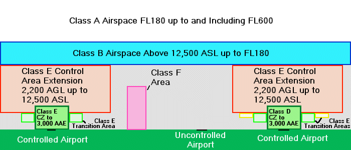
The major airports in Canada are surrounded by controlled airspace, mostly Class D control zones. These control zones are built from the surface up to a specified altitude, typically around 3,000 feet above aerodrome elevation (AAE). These can be other classifications as well. Outside of most control zones are transition areas, typically based at 700 feet AGL. Then there are control area extensions outside of these areas, and they are normally based at 2,200 AGL. Depending on the area involved, many areas go to uncontrolled airspace between airways, so the base of controlled airspace might then become "above 12,500 ASL", meaning that 12,500 itself is uncontrolled. Above 12,500, if it's controlled airspace, it becomes Class B airspace. Some outlying areas actually have the base of controlled airspace up at 18,000 feet ASL, or FL180 as we know it.
Whatever the base, controlled airspace is designated where it is determined that safety will benefit from the establishment of such additional structure. As mentioned earlier, controlled airspace increases the weather minima for VFR flight, in theory giving pilots of both IFR and VFR aircraft a better chance of seeing each other. The control area extensions and, in particular, the transition areas established near airports are place there to allow IFR aircraft to conduct IFR approaches with that very restriction: to force VFR operations out in lower weather to increase the margin of safety for IFR flights. Commonly used tracks, mostly based on NAVAIDs, are typically located within controlled airspace as well, since historically they are frequented by IFR aircraft. Outside of airspace commonly used for IFR flights, you'll often find uncontrolled, or Class G, airspace. Given the way the airspace is actually designated, the common description is often considered to be an upside-down wedding cake. Have a look at the following diagram.
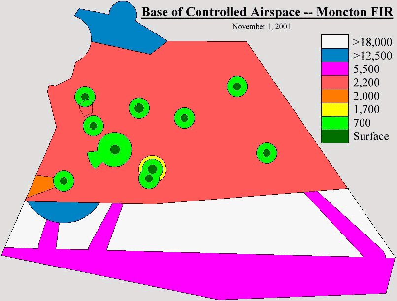
To give an idea of what an FIR looks like when the base of controlled airspace is plotted out, I've included the following diagram to demonstrate.
You can see the designations in place, and just how many there are; and this is a relatively non-complex area. The red areas are part of the "Maritime Control Area Extension", a region described within the Designated Airspace Handbook, a Transport Canada publication. All of the dark green areas are control zones, whether they be Class D or E in this case, where controlled airspace extends to the surface of the earth. The light green are the control area extensions, as is the yellow area surrounding Halifax in the middle of the FIR. The blue area in the bottom left as also part of a transition area surrounding Yarmouth, NS, CYQI. The orange area to the left hand side (west of YQI) and the purple areas extending southward are actually oceanic routes to get out to the oceanic airspace in New York's FIR. The purple bar at the bottom is actually oceanic airspace. Looking north, the blue area at the top of the FIR is also based above 12,500 ASL. You can also see an area outlined in black between YSJ and YFC on the left-hand side of the picture between two areas of green. This is actually CYR724, Class F airspace capped at FL250. At the time I completed the diagram, the airspace was actually contained within the Maritime CAE, and therefore would be considered to have a base of 2,200 AGL if it were released to Moncton ACC for control, as is occasionally the case.
VatSim Hardships with Airspace Classes
VatSim has it's own ups and downs in dealing with controlled airspace. Not all controllers are aware of the boundaries, or even the differences, between controlled airspace and uncontrolled airspace procedures. Not all pilots are, either. Different levels of experience and knowledge often clash and provide pilots with confusing notions of what they are supposed to be doing, and what they are required to do. Different pilot experience and knowledge levels present controllers with frustrating times at the "sector", too. Also, the fact that a pilot is often in an area that was being treated as uncontrolled due to a lack of ATC, and suddenly ATC joins and takes the helm plays a part. Then, the pilot who was flying along, thinking there is no ATC, suddenly gets an unfriendly blast from a controller, warning him to check for ATC. Here are some things we should be doing.
Pilots, always be aware of where you are. Whose FIR you're in can be confusing sometimes, but no ATC should ever get impatient with you for asking. I know, they do sometimes. They shouldn't. This is not a big deal. Personally, as ATC, I'd rather a pilot ask me in advance to clear things up rather than do something wrong and have both of us "suffering the paperwork". Keeping an eye on what FIR you're in will let you know who you should be looking for online. This also means you should be familiar with some FIR idents in the VatSim world, so you know whether your current FIR is online. Any controller *should* be familiar with the surrounding FIR names, so if you call in, ATC should at least be able to tell you if the appropriate region is online and perhaps help you learn their name.
If ATC is not online for the area you're flying in, treat it as uncontrolled airspace. Make altitude changes considering traffic you may know about (by TCAS, by reports, etc). If ATC is online, make sure you know if you need a clearance to do what you want in the airspace you're in. As you can see above, most IFR operations require a clearance to do just about anything for IFR flight. Only in Class G are you safe to operate without clearances, and sometimes controllers may not be aware, depending on their background and experience, just where Class G airspace lies in a region. For example, last night you might have flown from an airport that the controller online as CTR told you was uncontrolled, so taxi and take-off were at pilot's discretion. Tonight, the controller gets mad when you taxi out on your own and insists you require a take-off clearance. Take it easy and don't get too mad about it. Perhaps asking for clarification and informing ATC of the discrepancy might just lead a controller to ask someone else about it and learn something in the process. If you're online ATC reading this, are you aware of the various classes of airspace in your FIR? If not, check some charts and consult with others, especially your FIR instructors, to see if they know. Also, check to see what has become standard for the FIR, since local practices often evolve.
Pilots should be checking periodically while flying if they're not in communication with ATC already. Any time you are about to enter a new FIR, have a look. This includes oceanic FIRs, places with known terminal areas, and while on approach to ensure a tower hasn't popped up since you started out. Periodic checks while flying in an area previously thought to be dormant are also a good idea.
Controllers could be a little more forgiving of folks zipping through, too. A friendly message reminding a pilot to check for ATC, rather than an ALL-CAPS FLAME stating how stupid he is for not checking, is much better received. Remember, we're here for entertainment and learning, so keep it civil. Any real pilot knows that a friendly ATC is better than a grumpy one, and the same goes for VatSim.
Another thing controllers could do is answer pilot's questions politely, rather than get mad at them. The pilot who is smart enough to ask deserves a good answer. Whether it is regarding the class of airspace surrounding the aircraft, what the pilot is expected to do, or even who the pilot should be talking to, a reasonable tone of voice (or text) should be used when the answer is delivered.
More will follow in coming weeks as we delve further into the concepts of VFR and IFR flight within the various classes of airspace. I'm always open to feedback, positive or negative, so e-mail me at mo@xlii.ca. Once again, thanks for reading!