Aviation Topic of the Week
Original by Michael Oxner,
March 30, 2003Updated May 4, 2022
This week's topic:
IFR Altitudes: Cruise and Descent
Cruising Altitudes: Definitions for IFR and VFR
Selection of Cruising Altitudes
When to Start Descent for Landing
Altitudes on Approach to Landing
Cruising
Altitudes: Definitions for IFR and VFR
I have had a few requests with respect to altitude usage when flying IFR, in
particular while on approach, both with and without ATC online. First, I'll
start by attempting to clarify cruising altitudes and the selection of those.
The Canadian Aviation Regulations specifies which altitudes may be
used for cruise flight, and rules exist there for both IFR and VFR, and they
make reference to direction of flight. Some definitions might be handy, at this
point.
Altitude: When referring to cruising flight, these are altitudes measured Above Sea Level (ASL) as indicated on a standard aircraft barometric altimeter that has been corrected for local barometric pressure by using the local station pressure (AKA altimeter setting). Radiotelephony for altitude reports and assignments includes speaking the altitude in grouped form: how many thousands and how many hundreds, noting that the thousands digits are to be spoken separately. That is
to say 12,000 is, "one two thousand," not, "twelve thousand," and 4,200 is, "four
thousand two hundred," not, "forty-two hundred," and always in reference to sea
level, not ground level or airport elevation. (The term "height" is often used
when making reference to ground level.)
Flight Level: In Canada
and the US, above 18,000 feet ASL, we set our altimeters to standard pressure
(29.92 inches of mercury or 1013 millibars) and maintain altitudes as indicated on the same altimeter setting. This is our "Transition Altitude". Altitudes above this Transition Altitude/Level are referred to as "Flight Levels" and are expressed in multiples of hundreds of feet. 20,000 would be expressed as "Flight Level Two Zero ," never omitting the term "Flight Level" or abbreviating it to "Level," which could be confused as, "reporting level." As you climb above 18,000 feet, set your altimeter from the current station pressure you were given on departure with your clearance or your taxi instructions to the standard pressure setting. When descending through FL180, set it to the current station pressure for the destination aerodrome. Flight Levels are also used over the ocean and in other areas where there are few weather stations capable of reporting a barometric pressure for use in aircraft, such as the Canadian far north. Note that when set to 29.92, your altimeter will only show your
altitude above sea level when you are flying over a point where the barometric
pressure happens to be 29.92. This means that you may be higher or lower than
your altimeter is indicating. Another term for this is "pressure level." The
key here is that the other aircraft that are flying near you will also be using
an altimeter with approximately the same amount of error, so you will still
have 1,000 feet between your flight levels as you pass.
As an aside, Europeans will refer to FL200, FL300, and FL400 as "Flight
Level Two Hundred," "Flight Level Three Hundred," and, "Flight Level Four
Hundred," respectively. This is to help differentiate between FL200 and FL220,
FL300 and FL330, in particular as it's easy on a clear radio transmission to mix
these up unintentionally, and even easier on a bad radio with lots of static.
Still other jurisdictions in the world report and assign altitudes in meters,
but that's beyond the scope of this article since we don't use meters in
aviation in Canada.
I'll assume you know IFR and VFR. Do you know CVFR? Controlled VFR
flight is still accomplished in visual weather conditions with visual reference
to the ground, but it takes place in Class B airspace. You must be in contact
with ATC and receive authorization to operate within Class B airspace. This
authorization is to be treated just like an IFR clearance: You'll be assigned a
route of flight and an altitude and expected to fly both. The difference is
that you are still responsible for keeping out of cloud and seeing the ground
for navigational reference. If the clearance issued by ATC would have the
aircraft operating in cloud, the pilot must advise ATC as soon as possible to
obtain a modified clearance that will permit the aircraft to remain in visual
conditions. Climbs and descents must be requested and approved before the
commencement of either, and routing changes (including turns) must also be approved.
Reading back the clearance to the controller constitutes acceptance by the
pilot. If it is unacceptable -- such as the case where a route would take the
VFR aircraft into cloud -- it must be stated along with the reason so ATC can
make alternative plans for traffic flow. ATC provides IFR separation between
IFR and CVFR aircraft, and between CVFR aircraft and others operating under
CVFR, so they have to know what you're doing and also require control over your
flight path to be able to provide this separation. Hence the requirement for a
clearance. While Class B may be designated elsewhere, Class B airspace is
generally known as, "Controlled low level airspace above 12,500 up to and
including 18,000 feet."
"Low Level airspace" is up to, but not including 18,000 feet, while "High
level airspace" is 18,000 feet and above. FL180 is considered to be above
18,000 feet, and therefore part of the high level structure. 18,000 feet
doesn't exist as a cruising altitude in a sense, since that's where we
transition to Flight Levels in Canadian (and US) airspace. The transition level
varies around the globe, so check your local regulations.
For IFR flight, it generally goes that westbound tracks take "even
thousands" while eastbound tracks take "odd thousands". VFR use the same
thousands, but add 500 feet for good measure.
The following table gives an idea of how cruising altitudes are expected to
be applied. Normally 1,000 feet of vertical separation is required for IFR
aircraft up to FL290, and from there it goes to 2,000 feet (If you're thinking
about RVSM, just hold that thought for a moment -- there is a line for that in
the table, but it's mentioned afterward). This was considered necessary due to
errors in standard barometric altimeters in the higher, thinner, and colder
air.
|
Altitudes or Flight Levels |
Track 180-359 (Westbound) |
Track 360-179 (Eastbound) |
|
IFR and CVFR altitudes |
Even thousands (2,000, 4,000, 6,000, 8,000, 10,000, 12,000, 14,000 and 16,000) |
Odd thousands (1,000, 3,000, 5,000, 7,000, 9,000, 11,000, 13,000, 15,000 and
17,000) |
|
IFR Flight Levels, below FL290 |
Even levels (FL180, 200, 220, 240, 260 and 280) |
Odd levels (FL190, 210, 230, 250 and 270) |
|
IFR Flight Levels, FL290 and above |
FL310, 350, 390, 430, 470, 510, 550, and 590. |
FL290, 330, 370, 410, 450, 490, 530, and 570 |
|
IFR Flight Levels, FL290 to FL410 under RVSM |
FL300, 320, 340, 360, 380, 400 |
FL290, 310, 330, 350, 370, 390, 410 |
|
VFR altitudes |
Operating above 3,000 feet, even thousands plus 500. (4,500, 6,500, 8,500, 10,500, and 12,500) |
Operating above 3,000 feet, odd thousands plus 500. (3,500, 5,500, 7,500, 9,500 and 11,500) |
Aircraft track is determined by magnetic track in Canada's Southern Domestic
Airspace, and by true track in the Northern Domestic Airspace. Perhaps a topic
for another week? I didn't include altitudes above FL600, as so few aircraft
can actually reach those altitudes. For those who thought of RVSM, now is your
chance to shine. About 20 years ago, a lot of work was put into the idea of
using less vertical separation in the altitudes commonly used by commercial
airliners, all with the idea of making this more efficient. With the Reduced
Vertical Separation Minimum program, or RVSM, the vertical separation requirement
is reduced to 1,000 feet between aircraft operating between FL290 and FL410.
Special considerations must be met for aircraft and operators to receive RVSM
certification, but in VATSIM, we consider all aircraft to be certified. Within
RVSM airspace and the RVSM Transition airspace, outside of organized and
structured traffic flows, the pattern for the lower flight levels continues:
Even flight levels are westbound and odd levels are eastbound. Above FL410, the
cruising altitudes rejoin their previous designations for eastbound and
westbound. At the time of rewriting this article, all of Canada's high level
airspace and the Oceanic airspace delegated to Canada by ICAO between FL290 and
FL410 is RVSM airspace.
Selection
of Cruising Altitudes
Determining which altitude to use depends largely on the type of aircraft
you are planning to fly, but also on the weight of your load and the distance
you need to travel. Other basic issues include, but are not limited to, Minimum
Enroute Altitudes on airways (MEAs), terrain and obstructions in the flight
path, and restricted airspace along the route of flight. Advanced issues to
consider include temperature, winds aloft, pressure patterns and so forth.
Generally speaking, the higher you go, the more fuel efficient your aircraft
will be. There are limitations to this statement, though, perhaps better left
to another weekly topic. For a short hop, you may be better off staying low for
the cruise, rather than fighting hard to climb just to begin descent when you
reach your cruising altitude. I'll give a few examples of cruising altitudes
with distances (ignoring other factors mentioned above) for a typical Dash 8.
|
Distance to be flown |
Eastbound Leg |
Westbound Leg |
|
Less than 50 NM |
3,000 or 5,000 |
4,000 or 6,000 |
|
50-80 NM |
7,000 or 9,000 |
8,000 or 10,000 |
|
80-120 NM |
11,000 or 13,000 |
12,000 or 14,000 |
|
120-160 NM |
15,000 or 17,000 |
16,000 or FL180 |
|
160-200 NM |
FL190 or FL210 |
FL200 or FL220 |
|
More than 200 NM |
FL230 or FL250 |
FL220 or FL240 |
Note that this is only an example. There could be many reasons why some of
these may not be acceptable. Short hops through the Rocky Mountains would
preclude the use of 3,000 feet, for example, since even many of the aerodromes
are above 3,000. Strong westerly winds aloft might require a westbound flight
to stay lower than an otherwise-optimal altitude to get out of the headwinds.
Turbulence may dictate a higher or lower altitude, as could icing. The
altitudes mentioned above are simply observations of preferred altitudes based
on flight plans filed in the real world in the Moncton FIR.
Another interesting note comes for Flight Levels near the transition
altitude, including mainly FL180, FL190, and, though only occasionally, FL200.
When the barometric pressure is below standard, there would be less than 1,000
feet of separation between an aircraft operating at 17,000 with his altimeter
set to a local station pressure and an aircraft cruising at FL180 with his
altimeter set to 29.92. If the barometric pressure is below 29.92, FL180 is no
longer useable and ATC will not clear an aircraft to operate at that altitude.
Additionally, if the pressure goes below 28.92, as it does on occasion, FL190
also becomes unavailable by the same logic. If it drops incredibly low, below
27.92, FL200 would also be out the window. This rarely happens in Canada, as
pressures below 28.92 generally only accompany a very strong low pressure
system which means very bad weather and very high winds. 27.92 would be low
enough to stir hurricane force winds and nasty weather, and we just don't see
that very often in Canada. So when you see a barometric pressure below 29.92,
expect that clearance request to operate at FL180 to be shot down, and you'll
most likely be offered 16,000 or FL200 if you're heading westbound.
When to Start Descent for Landing
When flying, eventually you have to descend. When should you start down? How
low can you descend?
To sort of answer the first question, there are several "rules of thumb"
used for determining when to descend. Which rule to use, if any, comes more
from knowing your aircraft than anything else. Many people use the guideline of
3 Nautical Miles per thousand feet. If you're up at 15,000 feet, and your
destination aerodrome is at 1,000 feet ASL, subtract 1,000 from 15,000, and you
find that you have to descend 14,000 feet. This would mean 14 thousand feet
times 3 NM equals a "Top of Descent" at around 42 NM from touchdown.
While researching the Canadair Challenger 600 for a model I was building for
Flight Simulator, a real-world pilot gave me their guideline: Twice the
altitude in thousands of feet, plus 10 NM. So if you're at FL330 and your
airport is at 1,000 feet, you have to descend 32,000 feet, so 32 x 2 = 64, and
adding the 10 NM gives you 74 NM. At about 74 NM from destination, they would
throttle back and commence a descent at about 3,000 feet per minute.
Yet another method of determining when to start down is based also on
altitude to lose, but is based on ground speed, as well. For example, your
airport is at 1,000 feet, and you're at FL240, doing a groundspeed of 240
knots. This speed translates to 4 miles per minute. You have 23,000 feet to
lose (24,000 - 1,000 = 23,000), and you plan to adjust power to descend at
1,000 feet per minute. At 1,000 fpm, descent would take you 23 minutes. In that
time you would fly 92 NM (23 minutes times 4 NM per minute). Using this method
you would begin descent at about 92 NM.
In each case, it is important to consider the approach type and runway to be
used when thinking about the "distance from destination". If your course
happens to be lined up perfectly with the final approach course and landing
runway threshold, it makes for nice numbers. If you have fly past the airport,
fly base leg to join final at 10NM, you now have to understand that, between
you and touchdown, there are about 25NM more to fly than if you went straight
in on the opposite end.
Many aircraft have some form of FMS and will calculate everything for you,
including whatever STAR, approach procedure and transition you have configured.
This is by far the easiest to handle if there is no traffic in the way. If you
have to descend earlier or later than the FMS-determined "Top of Descent", you
may have intervene manually or make adjustments to the path.
Remember that if other traffic is in the way, you may end up adjusting your
plan. Simply requesting a descent doesn't mean you're going to get it. So my
suggestion is that you request descent a little early, perhaps even advising
ATC when you want to start down. "Center, ACA123, we'd like to start
descent in about 5 minutes," or you could specify a distance from
destination, "ACA123 requesting descent in 10 miles." Something like
that. This way, ATC can advise you if there is traffic or some other reason why
they can't issue a descent clearance right away, allowing you to alter your
planned descent rate, your forward speed once you commence your descent,
whatever. Stating that you're requesting descent right away is fine. Typically,
a flight requesting descent without any further information will be regarded as
being ready for descent right away. Upon receipt of a descent clearance ATC
will expect you to begin descent promptly at a normal rate of descent for your
aircraft type unless you ask otherwise. You should complete any pre-descent
checklists before asking.
Canadian ATC may use the term, "When ready," with a descent clearance. For
the old hands, this is roughly analogous to the former phraseology, "At
your discretion." When you receive a clearance like this, you may commence
descent at any time you are ready. Unlike the phrase "at your discretion," a
pilot is no longer allowed to temporarily level off at an interim altitude. For
this purpose, an "interim altitude" is just an altitude above that altitude to which
you are cleared. American ATC still use the older phrase. The only thing to
keep in mind is that you are expected to descend a "rate that is normal for
your aircraft type" unless ATC approves a request for something else, such as a
cruise descent.
Altitudes on Approach
to Landing
ATC will generally you and an altitude to which to descend. What if there is
no other traffic and the controller says, "Air Canada 123 is cleared to the Sydney airport for an approach"? In Canada, a pilot in receipt of an approach clearance is allowed to descend when ready to any altitude associated with an instrument
approach procedure at the destination airport or published on another chart
that is appropriate for the geographical area of concern. It's my understanding
that American rules mean that a pilot may not descend below the previously-cleared
altitude until the controlled explicitly says so. Unfamiliar American pilots
will often level off at the previous altitude assignment and request lower, or
just patiently wait until they receive lower. Moving on.
 You would commence your descent at an appropriate time when conditions permit. How
low you go depends on several factors. As an IFR aircraft, you are required to
observe a Minimum IFR Altitude at all times in flight. This means 1,000 feet
above the highest terrain or obstacle within a 5 NM radius of the aircraft. To
aid the pilot in this respect, minimum IFR altitudes have been established in
many airspaces, and it's just a matter of picking the right one. For example,
if you're descending on an airway, don't descend below the MEA, or Minimum
Enroute Altitude, until you find another published altitude to allow you lower.
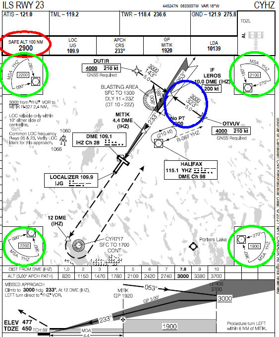
For example, you could use a 100NM Safe Altitude if you're within 100NM of the
airport, and this information is located on every approach plate for Canadian
airports (in the red oval at left). Or you could
use a "quadrantal" altitude from the designated fix on an approach plate (these are circled in green). This is generally the Final Approach Fix, and this is presented to you in corners of the plan view of the approach plate. You have to ensure that you're within the distance specified (standard is 25 NM) from the fix named, and also that you're
within a given quadrant for use of the specific altitude. Once you're established
on a published segment (between OTVUV and LEROS, for example), you can fly the
published altitude for that segment (in blue).
You would commence your descent at an appropriate time when conditions permit. How
low you go depends on several factors. As an IFR aircraft, you are required to
observe a Minimum IFR Altitude at all times in flight. This means 1,000 feet
above the highest terrain or obstacle within a 5 NM radius of the aircraft. To
aid the pilot in this respect, minimum IFR altitudes have been established in
many airspaces, and it's just a matter of picking the right one. For example,
if you're descending on an airway, don't descend below the MEA, or Minimum
Enroute Altitude, until you find another published altitude to allow you lower.
For example, you could use a 100NM Safe Altitude if you're within 100NM of the
airport, and this information is located on every approach plate for Canadian
airports (in the red oval at left). Or you could
use a "quadrantal" altitude from the designated fix on an approach plate (these are circled in green). This is generally the Final Approach Fix, and this is presented to you in corners of the plan view of the approach plate. You have to ensure that you're within the distance specified (standard is 25 NM) from the fix named, and also that you're
within a given quadrant for use of the specific altitude. Once you're established
on a published segment (between OTVUV and LEROS, for example), you can fly the
published altitude for that segment (in blue).
Generally, you use an altitude that will serve your purpose. For example,
the 100 NM Safe Altitude from the Fredericton, NB, NDB (FC) is something over 7,000
feet simply because it has to be above the highest terrain or obstacle within
100 NM of the fix and because that radius includes American airspace, meaning
criteria dictates 2,000 feet about the highest terrain/obstacle. Not very
useful when landing at an airport whose elevation is 67 feet. So look around on the IFR charts and approach plate you're using for other lower altitudes to get you down. There are airway altitudes that you can use if you're within the airspace for the airway and GASAs (Geographical Area Safe Altitudes, found on LO charts in Canada) that are based on widely spaced latitude and longitude blocks, as well as other sources. As long as you remain at or above an altitude until you find one that's lower, you're safe. Another trick we use in Moncton Center is the 100 NM safe altitudes of other nearb aerodromes. For example, because of the 100 NM Safes from YQI, YZX, YYG, and
YQY, we know that everywhere in the Maritime provinces south of YFC to F9
(Fredericton to Miramichi, NB) 3,000 feet is safe. The key is finding a
published altitude and ensuring you're in the airspace covered, which may be
difficult in the cockpit. You are not likely to have the time to review many
approach plates to find an altitude that's nice and low thanks to a nearby
airport while you're on approach to an entirely different one. This is where your
flight planning comes into play: Using the IFR charts to review the locations
of restricted airspace, high terrain and so forth while you're planning your
route of flight.
While we're on the topic of altitudes, you may be given altitudes that are
not published when you're being vectored to final by ATC. In areas where ATC
vectors IFR traffic frequently, Minimum Radar Vectoring Altitudes (MRVA) are
established. These are not published on any charts available to the flying
public. They are plotted to cover obstacles and terrain differently from
Instrument Approach Procedure (IAP) charts and this allows the "confinement" of
prominent obstacles. Rather than an entire quadrant raised to clear an
obstacle, an area of a higher altitude can be established immediately around
the obstacle to allow the area surrounding to be assessed for a lower altitude.
I hope I've covered this topic in reasonable detail without too much
reading. Anyone who knows me knows that I tend to be wordy at best. I hope you
found this information helpful, and will continue reading other topics, or
perhaps even ask about something for yourself. If you have anything to say,
good or bad, about this presentation, the information provided or lack thereof,
or anything else, please feel free to e-mail me at mo@xlii.ca . Once again, my
goal is to help, and feedback always helps.